October 12, 2022
We woke up to a knock on the door of our room in Sundar Homestay exactly at 05:30 a.m. It was Shailender, the multi-tasking person of the Homestay, with cups of tea in steel glasses. I had never expected that in mountains, we would get the bed tea so early. Even in Uttarkashi, a big town, we would have to wait for one more hour to get bed tea. I went out to the balcony with my bed tea in hand to observe the weather condition. In the twilight, the weather looked excellent for Lama Top trek which we will be attempting after the breakfast. The sun had risen by now. I went out for a stroll in the Harsil market. With the afternoon rains in the previous day, the upper reaches of the mountains surrounding Harsil seem to have received fresh snow.
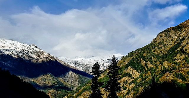

Morning view of Mt. Harsil Horns from the garden of Sundar Homestay.
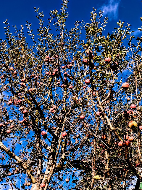
Red apples on the tree with a background of the blue sky in the garden of Sundar Homestay.
Trek to Lama Top (3+3Kms)
I became aware of Lama Top trek only few months back when I was researching on our proposed trip to Harsil. After watching a couple of videos on Lama Top trek, I felt that I must do this trek though it required a 3 kms of almost continuous climb, gaining around 400m in altitude to reach the top.
After finishing the breakfast around 9:00 a.m., we packed our respective backpacks with umbrella, some eatables and 1 litre of water bottle. We walked towards the main gate of Army cantonment to take an exit to the right and crossed the pedestrian iron bridge. The trek to Lama Top starts at the right turn after the bridge. Immediately, we were on a gradual climb which continued until we reached a viewpoint after about 20 minutes.


Starting point of Lama Top trek. The right turn at the end of the bridge is the route to Lama top. Photo by K. Srinivasan.

The initial part of the trek goes along Jalandhri River on the right side.

On the Lama trek path.

Some rest in the backdrop of Mt. Harsil Horns.

Harsil Valley with Harsil village seen from the trek route.
The main trek path is well laid thanks to the Jadh Bhotiyas of Bagori village who had done the initial laying down of the trek path to enable them to worship on Lama Top. There are some subsidiary paths and diversions on the initial part of the trek. Eventually, they meet the main trek path after few metres, So, there is not much worry about losing the path. The soft soil on most part of the path covered with dead leaves and dry grass and with almost 45-degree gradient of climb, and similarly ascend on return trek, the chances of slipping on the trek is high. This is especially so if trek path is drenched in rains.
It had rained in the previous afternoon in Harsil which continued till late evening. Our homestay guys had advised us to avoid trek to Lama Top if the rains continued on the next day. So, I would strongly advise to those who wish to visit Lama top to carry a trekking pole (or wooden stick) and wear shoes with good grip. Also carry some eatables and sufficient water as there is nothing available on the 3-km trek route.

View of Bhagirathi River from the trek route.
Despite steep climbs we faced, the good thing about this trek path is that we came across 3 viewpoints where we could enjoy the sceneries and at the same time get some rest to bring back our breathing to normal. In the entire 3-km of trek, we were the only two persons on the trek. It was only on our return trek we came across a Bengali lady who came with a guide.

From this point, it is a steep climb up to Lama Top.

Note the steepness of the climb from right. Still more to climb.

Looking at the prayer flags and the flat top, I first thought we have reached the Lama Top.

We also took a couple of pictures

After a steep ascend of about 20m on narrow stone steps off the rock cliff followed by equally steep climb, again on stone-made steps off the cliff, we reached the Lama Top. It took about 2 hours to cover the 3-km of distance. The first thing we observe on reaching the top was fluttering of hundreds of prayer flags because of the strong breeze. Yet there was no view of Harsil Valley. A climb of one step on a flat rock and standing on it gave virtually 270-degree view of Harsil Valley with Mt. Harsil Horns in the far-end and Harsil and Bagori villages with Bhagirathi River at the base of the Valley. I was looking at my shoes to ensure that I was standing firmly on flat rock to face the strong breeze, and that very moment I also saw the Harsil Valley down below.
It is interesting to note that in the morning, when I was in Harsil Street, I looked up to see the Lama Top Mountain which stood vertically. Now, I am on Lama Top, and looking down to see Harsil village. What a contrast. Another contrasting feature of the place is that though it is just 3 kms from the hustle-bustle of pilgrims enroute Gangotri and tourists in Harsil, Lama Top is a place for solitude lending a spiritual atmosphere. The pleasure of spending some time in deafening silence except the occasional sound of fluttering prayer flags on Lama Top is more than compensated by the hardship faced in steep climbing for reaching this place.
Lama Top is a worshipping place for the Jadh Bhotiyas living in Bagori village and around. It is a place for them to get their wishes fulfilled. First, they visit praying for their wishes be fulfilled. After their wishes are fulfilled, they visit once again for thanksgiving. At each visit, they host prayer flags as has been the ritual among the Bhotiya Buddhists.


Video of View from Lama Top


After spending about 30 minutes on Lama Top, we commenced our return trek. The weather had turned partly cloudy and the chances of rain showers after some time seems imminent. But the steep descend was also equally difficult in balancing oneself. Still, we could complete our return trek in about 45 minutes without taking any break and viewing sceneries. After reaching, we realised that we had unknowingly taken a different trek route which brought us down to a car parking place on the way to Bagori. So, it can be construed that those living in Bagori would use this trek path for Lama Top while those in Harsil would use the path on which we commenced our trek in the morning.
We returned to our Homestay by 01:00 p.m. After lunch, we had planned to walk 3 kms to Mukhba village to visit Maa Ganga temple and take a walking tour in the village. However, the continuous rains in the afternoon stretching till dusk forced us to abandon the plan.
No comments:
Post a Comment