This is my fourth year in a row on my visit to Uttarakhand, mainly covering non-touristry places, that too, during non-chardham yatra season. For this year, I selected Munsiyari as the base for exploring the nearby places. Nestled at an altitude of around 2300 metre above sea level, Munsiyari is one of the tehsils in Pithoragarh district of Kumaon region of Uttarakhand. It is an off-beat tourist destination and the base for some of the high-altitude treks such as Milam Glacier, Nandadevi East Base Camp, Namik Glacier, Ralam Glacier etc. Prior to Indo-China war of 1962, Munsiyari was one of the important routes for barter trade with Tibet.
I first came to know about Munsiyari when I was doing a trek to Adi Kailash in August-September 1993. The guide and a few of the support staff belonged to Munsiyari. They used to talk highly of Munsiyari which enticed me to include the place in my bucket list of places to be visited in future. However, I did not get an opportunity to visit Munsiyari either as a tourist or a trekker. The closest opportunity came to me last year when I had spent 3 days in Chaukori and had visited even Birthi Falls which is at the distance of about 35 kms from Munsiyari. But I was not interested in visiting the place just for the heck of it. I wanted to spend 3-4 days in Munsiyari to really get a feel of the place. So, when the plan for a short holiday in April 2025 was being discussed with my son, I suggested Munsiyari and he agreed.
 |
| Drive from Jolly Grant Airport, Dehradun to Munsiyari with a night halt at Gwaldam. |
Our day-wise activities after we landed in Jolly Grant Airport, Dehradun are as under:
Day-1: Dehradun-Gwaldam (1620m)
Our flight from Mumbai landed in Jolly Grant Airport almost 30 minutes before its schedule arrival of 11.00 a.m. We booked a pre-paid taxi outside the airport and started our journey to Gwaldam around 11.00 a.m. The Google map showed the distance of 250 kms which can be covered in about 7 hours without much of a traffic jam. We were happy that at least we would reach Gwaldam by sunset. When we reached just the outskirt of Rishikesh, traffic was moving at a snail's pace up to Laxman Jhula. Thereafter the traffic frequently stopped and moved slowly until we reached Shivpuri at around 2.30 p.m. So, it took more than 3 hours to cover just 35 kms. Our driver told us that for the last couple of years, it is a regular feature in this stretch during the weekend when the tourists from Delhi, Haryana and Western UP flock into Rishikesh for white water rafting, bungee jumping etc. We reached Gwaldam around 8.45 p.m. Luckily for us the rain showers had just stopped as we alighted from the taxi. We stayed at Nature's Treat Resort@1500/-for a double bedroom with a balcony.
I had visited Gwaldam in June 2008 for our onward trek to Roopkund. Since then, I had thought of revisiting the place mainly to view Trishul which I had missed in my last visit. So, it gave me an opportunity to plan a halt at this place before we proceed to Munsiyari, our ultimate destination.
Day-2: Gwaldam-Munsiyari (2300m)
The early dawn light from the window woken me up. I went to the balcony and found a cloudless blue sky with mist floating in the valley. This was a good sign that the weather will be clear to view peaks during the forenoon. The sun was rising from behind Mt. Nandaghunti. So, we will have to wait for an hour or so to click the pictures of the peaks when the sunrays would reflect on them.
View from our Hotel balcony in Gwaldam.
After finishing our breakfast, we commenced the journey by taxi at around 9.00 am for Munsiyari. The Google map showed that it would take about 6 hours to cover the distance of about 165 kms via Bageshwar-Kapkote-Kwiti road. We were told that the best peak views from Gwaldam is at around Gwaldam's '0' milestone on Karnaprayag road. As expected, we got the best and clear view of peaks of Nandaghunti, Trishul I, II, II, Mrigthuni, Devtoli and Maiktoli.
Peaks from left to right: Nandaghunti, Trishul-I, II and III, Mrigthuni, Devtoli and Maiktoli clicked from Gwaldam.
View from Gwaldam with author on the foreground.

Road going towards Bageshwar through Pine tree forest.
After continuously driving from Gwaldam via Bageshwar-Kapkote road, we took our tea break at a place known as Ramari Viewpoint (about 120 kms from Gwaldam), probably the highest point on Kapkote-Bhanar part of the road. The break was worthwhile for its scenic views of Ramganga River valley. Shortly, thereafter we took our lunch break at a tri-junction where road from Kapkote has two diversions - on the left to Munsiyari and the right to Thal.
Tea break at Ramari Viewpoint on Kapkote- Munsiyari Road.
Winding road ahead before we cross to the other side of the mountain over Ramganga River for our destination, Munsiyari.
Our lunch break point near Kwiti.
After lunch, we passed through Birthi Fall and Girgaon from where the steep climb with many sharp and hair pin curves starts up to Kalamuni Top (approx. 2900m). From here one gets the best view of Panchachuli range. Unfortunately, the sky was cloudy and as such there was no point in taking a break at this place. We continued our journey and reached Munsiyari around 3.15 pm. We stayed at The Pinewood Homestay near KMVN Rest House@2000/-. After evening tea at our homestay's rooftop cafe, we strolled through Munsiyari market and bus/taxi stand. The placed looked almost deserted as the tourist/trekking season is yet to begin.
The quite Munsiyari Market area with taxi/bus stand.
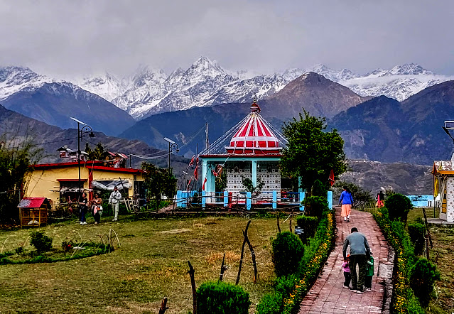
Since it was still bright even at around 5.30 pm, we decided to walk to Nandadevi temple which is located about 2 kms from the Munsiyari market through a short-cut and about 3 kms of drive on the road from Munsiyari market. We decided to walk to Nandadevi temple. We reached the gate of the temple in about 30 minutes. We were lucky to see the peaks of the Nepal side getting cleared from the cloud and Panchachuli peaks partly covered with haze and mist. Nandadevi temple complex has a well-maintained park and open ground, good enough for an evening relaxation with family and friends. We returned to our homestay by walk around 7.00 pm.
Nandadevi temple in the late evening with Panchachuli peaks partly visible in the background.
Peaks towards Nepal side seen from Nandadevi temple complex.
Day-3: Trek to Thamri Kund (2800m) and Visit to Darkot Village.
Once again, I was woken up by the early dawn light seeping through the window curtains at around 5.30 pm. From the balcony of our homestay, I could clearly see the shapes of Panchachuli peaks on which the sunlight was yet to reflect. The time for the sunrise for the day in Munsiyari was 5.42 a.m. I waited for some time to let the sunlight reflect on the peaks. The light first reflected on Panchachuli-II being the tallest among the Panchachuli peaks. So, I got the first picture of the day with sunlight reflecting on the top of the Panchachuli peaks.
Sunlight reflecting on Panchachuli peaks as seen from our homestay balcony.
A zoom shot of Panchachuli peaks clicked from our homestay balcony.
Our main activity for today was a 3-km trek to Thamri Kund from Betulidhar, 10 kms from Munsiyari towards Kalamuni side of the road. We hired a taxi which dropped at Betulidhar around 9.30 am. By that time, the sun light was fully reflected on Panchachuli peaks with a cloudless blue sky. Soon we started the trek which is mostly easy with a few patches of moderate climb The entire trek route was through the dense forest, mostly of Oak, Cedar and Rhododendron trees. I also noticed a few Thunair trees on the way whose leaves are used as traditional medicines and dry barks are powdered for use in the tea. Throughout the trek just before reaching Thamri Kund, Panchachuli peaks were our 'constant companion'.
Initial part of the trail to Thamri Kund.
Panchachuli peaks seen through the forest on the trek to Thamri Kund.
The highest point on the mountain is Khaliya Top seen from the trek to Thamri Kund.
On the top-most point of the trek with Panchachuli peaks in the background.
From the top-most point of the trek, the Thamri Kund became partly visible in a bowl-shaped valley. A descent of about 200m brought us to the shore of the Kund at around 11.00 am. The water was crystal clear. The proof is that the blue sky with surrounding trees got clearly reflected in the water of the Kund. On the northern side of the Kund, there is a small, raised platform made-up of stones, probably used by the locals for worshipping at the Kund. We started the return trek by taking the round of the Kund.
View of Thamri Kund from the top point of the trek.
Close-up of the Thamri Kund with reflections.
While on our return trek, we found some tourists with family and children undertaking this trek. A mix of white and grey clouds had started hovering around the peaks. It was an indication that the window of the clear blue sky with peaks would be closed very soon. So, we clicked some last-minute shots of Panchachuli peaks before we reached to a point with a shepherd's hut around which there were hundreds of goat/sheep grazing on a small meadow.
Grey clouds and haze have already covered the lower parts of the peaks while returning.
A large number of goat/sheep are resting near a shepherd's hut while returning from Thamri Kund
On way back from Thamri Kund. In the background is Munsiyari town.
End of the trek at Betulidhar with Hanuman temple on the gate side.
After lunch, we visited Tribal Heritage Museum on our way to Darkot village, It is a private museum owned and curated by Sher Singh Pangtey who has been collecting artifacts of this region for many years. The Museum has artifacts mostly of Bhotia tribes who have their settlements in the various border districts of Uttarakhand. With the period of time, the Bhotia tribal culture has undergone sea changes due to their exposure to the modernity. This museum is a reminder to the current generation of their cultural heritage. Photography is prohibited inside the Museum.
A further drive of about 5 kms on Munsiyari-Mudkot road took us to Darkot village which is known for hand-made Pashmina Woollen garments. Almost every house in the village is a cottage industry for Woollen garments. Unfortunately, the biggest of them was closed for the day. So, we visited the place of another family who were busy with the birthday party. So, we could not witness the making of the wool or the making of the garments. The entrance to the village is through a common gate which also goes to Maa Durga temple which has been completely renovated through the contributions of the villagers. We returned to our homestay in the early evening.
Tribal Heritage Museum, Munsiyari. Entrance to Darkot village. On the right is Maa Durga Temple.
Maa Durga Temple, Darkot.
View from Maa Durga temple. On the left is Goriganga River.
Day-4: Trek to Maheshwari Kund
The morning began with a cloudy weather with not a trace of any peaks from our balcony. Even though sun did come out of the cloud, but it turned out to be the play of hide and seek. We did not mind as we had the heart's content of viewing Panchachuli peaks with blue sky for nearly six hours during our trek to Thamri Kund yesterday.
We took a Max to drop us at the road head which is approximately 4 kms from Munsiyari market on Munsiyari-Thal road towards Kalamuni. On a hindsight, we felt that we could have walked to the starting point of the trek. The entry to Maheshwari Kund trek is free. We were joined by a boy who has given his 10th examination and was waiting for the result. He occasionally comes here with his friends for fishing in Maheshwari Kund. His ambition is to become a professional singer after completion of his graduation.
Entry gate to Maheshwari Kund trek
We commenced our trek from the gate around 9.30 am with a pleasant weather. The trail was of about 1.5 kms with a moderate climb mostly on a pebble path with forest cover. The boy accompanying us revealed that there are wild animals such leopards, musk deers who visit Maheshwari Kund for quenching their thirst. The boy showed us 5-6 varieties of birds such as black Bulbul and a Drango type of bird with a long tail. after the end of the climb, we walked about 200m on a small meadow before reaching a small Kund which was almost dried. We would have returned from this point thinking it to be Maheshwari Kund. But the boy told us that the Maheshwari Kund is about further 100 metres away, almost concealed by the dense forest surrounding it. The water was clyster clear with occasionally trout fishes disturbing the calmness of the water. It was a serene and a peaceful place. I made the boy accompanying us to sit at the shore of the Kund and sing a Kumaon folk song. The boy sang the song very well reflecting the emotion in the song with his expressive facial gestures. Indeed, the boy has the voice to become a professional singer.
Start of Maheshwari Kund trek.
Trail entering the dense forest.
View of Munsiyari with Helipad (top right) from the trail.
After experiencing about 30 minutes of solitude at the shore of Maheshwari Kund, we commenced our return to the road head. On the way, we spend about 15 minutes in a meadow for photo shooting from various points. Another 15 minutes of walk on the trail brought us to the road head from where this time we walked 3 kms to reach our home stay. Since we had not eaten anything during the trek, the first thing we did was to have chole-samosa at an adjoining restaurant with tea.
A level walk on a small meadow before reaching the first Kund.
Walking back on a meadow towards the road head.
An exotic bird, identified as 'White-throated Laughingthrush' during trail to Maheshwari Kund.
Last stretch of trail before the road head.
Since we had enough time for lunch, we decided to explore the Munsiyari Helipad which is barely 500 metres from our homestay. During our stay in Munsiyari, we have observed that the first helicopter from Haldwani lands in Munsiyari in the early morning and the second one lands around early afternoon. So, this was the perfect time to visit the Helipad when no helicopter flight is due to land. We felt that since it was located at a higher level, we may get some good views from the Helipad.
From the road head, we climbed about 50 steep steps to reach the Helipad which is not the official entry point for the passengers. There is a separate road for official entry for passengers who can enter with flight tickets. When the flight is not due for landing, anyone can roam on the Helipad. In fact, we noticed that the Helipad is being used by the locals in the evening as the meeting points for friends. The interesting point for the helicopter passengers is that as soon as they get down from the helicopter, the first thing they would see from the Helipad is Panchachuli peaks if the sky is clear. From the Helipad, we got a magnificent view of Munsiyari market area from one side and the valley view from the other side.
Munsiyari Helipad - One km from Munsiyari market and taxi-stand.
Munsiyari Helipad with passenger terminal in the background.
View from Munsiyari Helipad. the road on the foreground goes to Munsiyari market/taxi stand.
We had mini lunch at Himalayan Bristo, which specialises in Chinese menu. In the evening, we revisited Nandadevi temple by 2-km of walk from our homestay. We liked the place for strolling in its vast complex which was very well maintained.
Nandadevi temple in the late evening.
Day-5: Trek to Khaliya Top
It was the second day in succession that snow peak view was marred by the haze as well as partly cloudy sky. In the spring and summer months, haze formation has become a normal phenomenon in the mountains which gets mostly cleared by rain showers. It has not rained for the last two days in Munsiyari except some drizzles in the night.
Mood of the weather in Munsiyari in the early morning.
We started our journey to Khaliya base at the road head about 8 kms from Munsiyari by a Max. We reached the entry gate around 7.30 am which is the opening time. An entry fee of Rs.60/- per person is charged for the trek by the Forest Office. We commenced our 6 kms of a steep climbing trek in a cloudy and a misty weather.
Starting point of Khaliya Top trek.
The steep climb.
Mist passing over the trekking path to Khaliya Top.
The pink rhododendron on the trek pathway. There were large numbers of rhododendron trees with blooming red and pink flowers on the trek route.Unlike my last two days of treks (Thamri Kund and Maheshwari Kund treks), on this trek, I was taking more time to bring my breathing to normal for every 20-30 steps. First, I thought that it was due to the continuous steep climb. As I reached near the 1-km mark, the time to bring my breathing to normal increased to 10 minutes and thereafter it never came back to normal. It is at this point I felt that it was mainly due to feeling heaviness in my chest giving me a dull pain in chest and neck side. Most probably, I became the victim of pollen allergy (I am allergic to dust and pollen). Unfortunately, I had forgotten to take anti-allergic capsule during the last three days of the treks. Being the springtime, the level of pollen in the atmosphere is very high. I decided to discontinue trek and return to our homestay. I checked the weather forecast for Munsiyari which indicated a high level of pollen in the atmosphere. My respiratory discomfort continued until I took the anti-allergic capsule in our homestay room in the afternoon. So, my dream of doing the trek to Khaliya Top remained unfulfilled. I spent rest of the day in the room of our homestay and by evening I was in my normal self. It was our last day in Munsiyari.
Our return Journey to Mumbai with a night halt at Gwaldam and near Jolly Grant Airport, Dehradun was completed as per our schedule.
Mood of the weather in the morning as we commenced our journey from Munsiyari to Gwaldam.
From Gwaldam, a 2-km walk on Karnaprayag road took us to a Buddhist temple.
At Devprayag with the confluence of Bhagirathi River (green water) with Alaknanda River.
In the evening, we visited Har Ki Pauri, Haridwar for Ganga Aarti.
At Nandini Homestay near Jolly Grant Airport, Dehradun where we stayed here for a night.
We were fortunate to get good weather with a couple of clear sky days to view snow peaks from Gwaldam as well as from Munsiyari. During our stay in Gwaldam and Munsiyari, the minimum and maximum daily temperature ranged between 8-9 degree and 16–17-degree Celsius respectively.