Part-1 covers Trek report :Dharchula-Dar-Bongling-Sela-Baling
Day-4 : Baling-Dagtu-Son ( 6 kms of trek)
The overnight rains accompanied by thunder and lightning disturbed my sleep frequently in the night. In sheer desperation, I got up quite early in the morning to see how the weather looked like. It was still raining moderately when I came out of the room but a small patch of blue sky on the eastern horizon with mist hanging over the village gave some hope of improvement in the weather. As the breakfast ordered from an adjoining house was being served, rains eventually stopped but the sky was still cloudy when we departed from Baling. Our plan was to take a lunch break at Son and start for the Panchachuli Base Camp (PCBC) if the weather remained good. The other option was to stay put in Son village and try PCBC the next day early morning.

Baling village partially covered in mist

With some 'freight' boys on way to Dagtu
The first 2 kms of trek from Baling was a level walk through the fields mostly of Ugal/Palthi. The next 2 kms of trek, with a mix of short climbs and descents took us to a high plateau by the side of Dhauliganga gorge. The markings on the farm land indicated that they were the clusters of farms which seemed to have been left untended by their owners ( who probably shifted permanently to cities and towns). Instead, these farms had turned into meadows with varieties of wild flowers. The last 2 kms of trek before Dagtu village was once again a level walk through fields and meadows. Variety of wild flowers lent beauty to this stretch of trek.
 Wild flowers on way to Dagtu
A group of 'freight' boys, who were carrying materials required for the ongoing construction of KMVN Rest House at Baling, gave us the company during this part of the trek. One of the interesting things they told us about this area was that there was a mud hill in the shape of Qutub Minar on the left bank of Dhauliganga river. When we reached that point, the shape on the mud hill was looking more like a temple than Qutub Minar as the top portion of the mud hill in the shape of a minar had collapsed during heavy rains some years back. As more and more erosions take place due to rains and the flow of the river, even the temple shape may not remain for long.
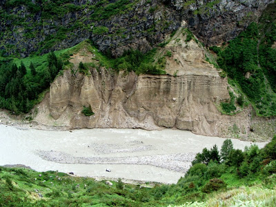
Mud hill in temple shape on the bank of Dhauliganga
 A bridge over Dhauliganga gorge for Chal village
After about 2 kms of walk, we reached a place surrounded by flat land on high plateau. On the opposite side of river were two villages - Bon and Filum, the former looking the bigger of the two - under the base of a high mountain range which the local villager called Bon peak with glacier coming down from its base and turning into a stream to join Dhauliganga.
Somewhere in the middle of this trek route, Dharam Singh Sonal, the Post Master of Dagtu village met us. It was at his house in Son where we had planned for the overnight stay. He said that he was going to Nagling post office to hand over the dak and collect the dak meant for Dagtu and adjoining villages. He assured us that he would be back by 2.00 p.m. Since his house was locked, he requested us to take the temporary shelter in his store room.
Walking over the meadow towards Dagtu
Before moving to Son, we had tea break at in a dabha at the entrance of Dagtu village. Son village is about 1 km ahead on a higher plateau. As we came to know later, Son-Dagtu villages have a common Gram Panchayat (Village Council).
The rains stopped around 2.30 p.m. but the sky was still cloudy. Dharam Singh had not yet arrived from Nagling. So we just passed time taking a round of Son and Dagtu villages. Son village was smaller as compared to Dagtu and it did not have any dabhas or shops. Nearly 50 percent of the houses were locked as the owners had migrated to cities and towns for work. A few houses looked like as if they were not occupied for years. From Son, one could have a bird’s eye view of the plateau on both sides of the Dhauliganga gorge which is so deep that river cannot be seen from any of the five villages unless one walk up to the exposed table top plateau towards gorge. On the right bank of the river are the villages of Dagtu, Son (pronounced as Saun) and Dantu and on the left bank is the Filum and Bon villages (pronounced as Baun) which seemed to be the biggest of the five villages. All these villages lied within a radius of less than 2 kms from one another. Both Dagtu and Dantu villages are located at the confluence of Meola river ( Also known as Nyuli river) and Dhauliganga river – the former in the right and the latter the left bank of the Meola river.
 Dharam Singh Sonal, Dagtu Post Master
 A meeting of Dharam's relatives in his court yard
Dharam Singh arrived at around 4.00 p.m. He was delayed as his wife who was coming from Dharchula reached late at Nagling. About a fortnight back, she had gone to Dharchula as her two daughters were studying there. After leaving them in the care of one of their relatives, she has returned to Son to help her husband in their farms. From the window of the room we stayed, the route to PCBC as well as Panchachuli massif was visible though peaks were covered with clouds.
Me with Jaswant Singh Sonal in Son Photo by K Srinivasan
We met Jaswant Singh Sonal [who is known as Chacha (Uncle) because he has three nephews in Son including Dharam Singh], in the court yard of his house located just opposite Dharam Singh’s house. He has a big house in which he stays with his wife in summer. During winter, unlike other villagers who migrate to towns like Dharchula, Sobla and Jualjibi, Jaswant Singh and his wife stay with his son who is a doctor by profession in New Delhi. Even though, Jaswant Singh could stay comfortably in Delhi even in summer, he prefers to face the harsh life of Son village as this gives him some time to pass by way of daily work at his farms, tending cows and sheep and above all the opportunity to chat with his three nephews and their families.
Day-5 : Son-Panchachuli Base Camp-Son (4+4 kms of trek)
We had planned to start the PCBC trek at 5.00 a.m. But the intermittent rains in the night which continued in the morning put spoke to our plan. Though rains receded by 9.00 a.m., the villagers advised us to postpone the departure to PCBC until rains stopped completely as there were some slippery paths on the way to PCBC. We commenced the PCBC trek at 10.15 a.m. as it has not rained for almost 1 hour and the weather was showing the sign of improvement. We took a chance with a wishful thinking that by the time we reach PCBC, the sun will come out and we would have a good view of Panchachuli peaks.
 A woollen carpet in the making in Son
After a gradual climb of about 1 km on a narrow path, we walked over a small meadow after which one more gradual climb of 1 km led us to another meadow where KMVN had built a shade for trekkers to rest. As rains started once again, we waited in the shade for about half-an hour before we moved further. A vast expanse of bugyal was in front of us which had dense forest on its left and gradual slope to the right ending at the Meola river bed. As we reached the PCBC (3470m, 21C), the bugyal ended as a steep slope to the right to Meola glacier snout while the left of the bugyal descended to Panchachuli massif. We were happy to accomplish our goal of reaching PCBC though there was some disappointment of not able to view Panchachuli peaks as clouds continued to act as curtains on the peaks even after spending about an hour at the PCBC.
 Wild strawberries on way to PCBC
 One of many bugyals on way to PCBC
 A stretch of moderate climb towards PCBC
The entire trekking route of about 4 kms to PCBC is very picturesque. There are bugyals, covered on one side by the dense forest of birch and coniferous tress, wild flowers all the way to PCBC, wild strawberries by the side of the trekking path ( we ate some which were tasty), many waterfalls around PCBC ( I counted 16 of them but I may have missed some). PCBC is a place where you get to see Panchachuli range from top (peaks) to bottom (massif) and the snout of the Meola glacier from where Meola River originates. It would be a good idea to stay for a night in tent at PCBC to explore the entire area which, in my view, would be interesting. The adventurous trekkers can extend the trek beyond PCBC by trekking about 2 kms to cross the Meola glacier and return to Dantu village from the left bank of Meola river. There are, however, some risk, especially in rainy season, of crevasses on the glacier covered by moraines and also the rock falls from the adjoining mountains. In early summer (April), one can have the pleasure of sliding on the snow about 1 km before PCBC to reach the Meola river bed.
 Meola glacier snout as seen from PCBC
 KS and me hold the ice-axe in PCBC with Meola glacier in background
 Debu performing puja at zero point at PCBC
 A small lake on way to Meola Glacier
As we were about to return back, a shepherd came to meet us. He introduced himself as Vinod and said that he stayed alone in PCBC during summer ( May-October) with his 300 goats and sheep. From his Hindi, I could guess that he did not belong to Darma Valley. Apparently, he was from a village near Pithoragarh and he was employed by the Government of Uttarakhand to tend these livestock owned by them. This was one of the many schemes of the Government to spur the rural employment. At the end of one month of his duties, he gets leave for a week or so during which time a reliever comes to take charge. During winter, he is transferred to bugyals near Narayan Swamy Ashram. When I asked him as to whether he was not getting bored by staying alone in the vast expanse of PCBC, he said that after his father’s sudden death, he had to give up the school and take this job to look after his family at Pithoragarh. He said that a daily round to Dagtu and Dantu villages gave him some relief from the boredom. As he was on way to his tent, he requested all of us to have tea with him. Looking at the steep downhill path which only a Shepherd would know that there is a path, and also the fact that afterwards we would require to take a steep climb to reach our regular trek path, there was some reluctance on our part to accept his offer. But at the same time, none of us wanted to disappoint him by declining his offer. The tea was good as it was full of herbs – rather more of herbs than the tea leaves.
 Colourful wildflowers on way to PCBC
 Son village seen from PCBC trek path Photo by K Srinivasan
It was 2.30 p.m, when we returned to Son. After a good lunch, we had the company of Dharam Singh, the Post Master, who skipped his daily trek to Nagling due to rains. Dharam Singh is a graduate from Rohilkhand University. The post office (actually it is called branch post office which is linked to Dharchula main post office) was located in one of the ground rooms of Dharam Singh’s house. He works for six months in a year (May- October) and his salary includes the lease rental for the room given to post office. During our two days of stay in Son, we never saw the post office premises opened except for a few minutes in the morning just to show us a carpet weaving. In fact, there is no need to open the post office premises as the Dharam Singh is out to Nagling daily between 8.00 a.m. to 2.00 p.m. Almost all the dak meant for the villages are collected on the way to his house. Villagers who have some post office related work, come to his house rather than the post office. In a village setting where everyone knows each other officialdom and formalities are not necessary.
Dinner was taken a bit late as Mrs Dharam Singh had decided to prepare rotis made from Ugal flour which was a time consuming process akin to making dosa dough. The dinner of Ugal rotis, rice, rajma dal, mix of potatoes and lai leaves vegetable dish, radish salad garnished with some herbs and home made pickles was a great finale to our stay in Dharam Singh’s house. However, we could see some disappointment on Dharam Singh’s face as we politely declined his offer of murti ( home made alcoholic brew) before the dinner.
 Kitchen room in Post Master's house Photo by K Srinivasan
Day-6 : Son-Dantu-Tidang ( 7 kms of trek)
By now, it had become almost the predictable pattern of rains - rains in the night which continues till early morning followed by sunny weather. It was still drizzling when we were having breakfast and by the time we were ready to set off for Tidang, it was a fine weather all the way. Again the trekking path had become, more or less, predictable – descents from the starting village and ascents towards the approaching village.
 A grinding mill (left) on way to Dantu
The distance between Son and Dantu is about 2 kms – 1 km of descent from Son on the right bank of Meola river followed by 1 km of ascent to Dantu village on the left bank after crossing the bridge over the river. As we were near the bridge, Panchchuli massif with Meola glacier was visible though the peaks were partially obscured by mists. We waited for some time on the bridge hoping that mist would get cleared and we would have a grand view of Panchachuli peaks. But the luck was not in our side as peaks continued to be covered by mists.
 The valley towards Meola glacier seen from Dantu
We had planned for a short break at the house of Dayal Singh Datial at Dantu around 8.00 a.m. and the message to that effect had already been passed by Jaswant Singh Sonal, the Chacha of Son in the previous evening. An elderly woman (who turned out to be Mrs Dayal Singh) was waiting for us outside her front court yard probably to make sure that we did not miss her house. “ The old man is in the kitchen preparing tea for you and he will be soon out here” she said with an intended pun. Although we were happy to sit in the court yard, she insisted all of us to come inside the house to have tea. The her maxim is that a visit to a house is not complete unless the guests sit inside the house and had tea ( or murti). Soon Dayal Singh came out from the kitchen with cups of tea. He seemed to be a man of few words limiting his conversation to the bare necessatiy.
 An elderly Dantu woman laughs for taking her picture
After spending about half-an hour in Dayal Singh’s house, we took leave of them and marched towards Dantu ridge. As we reached the top of the ridge, the mist was getting cleared over the Panchachuli peaks. We waited for some time hoping that all the five peaks would be visible as soon as the mist got cleared out of the Panchachuli range. All we could see was the three peaks, one at a time, like a slide show . We consoled ourselves by saying that we would have one more chance to try our luck on our return trek I can bet that the best scenic view of the Darma Valley trek would have to be from the Dantu ridge. On the west side, a wide angle shot covers the Meola river valley in the foreground to Meola glacier with Panchachuli peaks forming the background. The south-east side from the ridge gives a panoramic view of all the five villages – Dantu, Dagtu, Son filum and Bon surrounded by green farms and meadows. Again, the north-west side gives an unobstructed view of Dhauliganga valley up to Dakar village.
 Partial view of Panchchuli peaks Photo by K Srionivasan
Another partial view of Panchchuli peaks Photo by K Srinivasan
A view of four of five villages from Dantu ridge
Get, set and ready for Tidang. View from Dantu ridge
As soon as we crossed the Dantu ridge, we trekked through the dense forest of coniferous trees with wild flowers lined up on both sides of the path. As we came out of the forest, we were into small meadows and fields. Gow village was visible on the opposite table top plateau. The entry to the village was through an iron bridge over Dhauliganga which surprisingly had roof. After about 2 kms of level walk, we reached Dakar village which had some of the best wood-carved houses. Most of the houses in the village looked deserted.
 Approach to Gow village after Dantu
 A Tidang lady carrying herbs for chatuney
Wood carving on the main door of one of houses in Dakar
A view of valley from Dakar village
After Dakar, we could see a distinct change in the topography of the area with trees giving way to shrubs and mountains on both side of Dhauliganga losing much of their greenery. After about 2 kms of walk on the stony path, we reached Tidang village by noon and stayed in Lato Singh Titial’s house. KS, down with a bad cold for the last two days, told me that he was not very much interested in trekking Sipu the next day as he felt that the rest for a day may give him some relief from the cold. Also after trekking through so many villages, we both felt that the trek was heading for a set pattern thus reducing the excitement. Hence we decided not to go ahead with the trek to Sipu as planned for the next day and start a return trek. Since there was enough time left during the day, myself and Chamu decided to visit Marchha, the next village after lunch and return to Tidang by evening. For this purpose, we needed to visit ITBP camp for registering our arrival at Tidang and get ILN endorsed by ITBP for moving beyond Tidang.

Tidang village on the bank of Lasser Yankti river
 Sagar with his sheep in the backyard of his house in Tidang
After lunch, myself and Chamu visited the ITBP Camp which was located about one km away from the Tidang on a table top land towards Dakar. Sagar, the son of Loto Singh took us by a short cut involving a steep climb. It took us about 30 minutes to reach the main ITBP gate. As we were about to enter the camp, six barking dogs came towards us as if they were going to pounce upon us. The timely intervention by an ITBP personnel saved us from these ferocious looking dogs. Sagar told me that these were the stray dogs of Tidang village now well looked after by ITBP. The person managing the recording of ILP had gone for lunch. Hence we were instructed to wait inside one of the ITBP quarters till the person concerned returned from lunch. One of the ITBP personnel made us comfortable and served us with mango juice. He was from a village near Bageshwar and was transferred from Leh to Tidang 3-4 months back. He said jokingly that for him Leh was nearer to Bageshwar than Tidang as he was in his home town in about 24 hours from Leh whereas it takes 3 days from Tidang to reach Bageshwar.
ITBP Camp in Tidang is one of the bigger camps in Darma valley with a helipad. It has its own captive power through giant generators. It has satellite telephone facility which is being replaced with BSNL service ( This will reduce the telephone rate from the present Rs.25/- per minute to Re.1/- per minute). By the time the ILP formalities were completed, it was already 3.00 p.m. As we were returning to our home stay place, it started raining. As we were now short of time, we dropped the idea of trekking to Marchha. When I returned to our home stay room, KS was out for a round of the village with his DSLR. A rest of about 3 hours must have rejuvenated him.
Tidang is located between high mountains on the left and the right bank of Lasser Yankti river. Sagar, the son of Lato Singh, who told me that Bharals and Must Deers come to the village from the mountain top. Some of the houses near the mountain sides were in depleted conditions probably on account of rock falls from the mountains during early summer seasons when melting snow from the higher reaches of the mountains brings with it the rock falls. From Tidang onwards, it is Lasser Yankti river which originates somewhere from Indo-Tibetan border and flows through Anchari Tal, Sipu and Marchha before joining Dhauliganga near Tidang. A wooden bridge over Lasser Yankti leads to trekking path for Marchha-Sipu on the left and Bidang to the right. Although Tidang is a small village as compared with Dagtu-Son-Dantu, the village atmosphere is lively.
Day-7 : Tidang – Nagling (16 kms of trek)
Our return trek commenced at around 7.00 a.m. under cloudy but pleasant weather condition. We had left the choice of overnight stay based on our capacity to trek during the day. The favourable weather condition facilitated in hastening our pace of trekking as within two hours, we had reached Dagtu ( 7 kms). With an hour break at Baling for tea and telephones, it took about another 3 hours to reach Nagling ( 9 kms). We could have continued the trek up to Sela ( another 5 kms) but refrained from doing so as Nagling-Sela stretch was a combination of steep descents and ascents with some stretches on boulder-strewen path. Also, the overnight stay Nagling would have given us one more experience of home stay in a new village. The house in which we stayed for overnight belonged to Phool Singh Naniyal who was also the Post Master of Nagling BPO located in one of the houses in the front court yard.
For the first time during this trek we faced cold breeze at Nagling even though it was sunny. Hence, the lunch was taken inside the store room of the dabha. The sunny weather gave us opportunity to get ourselves fresh with a mini bath – shaving and washing head, face, hands and legs. In the evening while taking a round of the village, Nagling peaks were partially visible in the west giving some hope that we could have a sunrise view the next day morning. In the evening, when Phool Singh met us in the front court yard, I asked him whether Dagtu Post Master visited him today and how much he himself is required to walk daily to exchange dak with other post offices. He said proudly that he had two ‘runners’ working under him to do that job. He pointed out that Nagling BPO was the oldest post office in Darma Valley. Pointing the painted board of the post office, he revealed that this board had not been changed since the start of the post office in early 1970s.

A wildflower on way back to Dantu
Day-8 : Nagling – Bongling (12 kms of trek)
When I got up around 5.00 in the morning, I saw through the window the blue sky without any trace of clouds. I and KS immediately rushed out of the room with our cameras to shoot the sunrise view of Nagling peaks. The peaks were indeed visible without any cloud but sensing that there would be still some time for the sunrise, we went to a nearby dabha for tea. Surprisingly, dabha was opened and tea was readily available at this time of the morning. At around 5.30 a.m., the first rays of the sun fell on the right side of the Nagling peaks and within 10 minutes or so, the all peaks were shining with golden colour. At least we could see Nagling peaks on sunrise if not Panchachuli peaks. KS pointed out that had we trekked to Sipu, we would have been in Dantu today to get a clear view of Panchachuli peaks. He was right as there was not a patch of cloud in any direction. Later KS pointed out to me (after returning to Mumbai) that Nagling and Panchachuli peaks belonged to the same range as seen from Wikimapia-Google Earth.
Nagling peaks at sunrise seen from Nagling village
It was once again a hot and humid day as we moved on towards Sela. It took us about 2 hours to complete the 5 kms of trek to Sela. After a tea break at Dev Singh Sonal’s dabha who was happy to see us back, we were on way to Urthing when we came across two major rockfalls points which were further damaged due to heavy rains during Tuesday night to Wednesday noon (14th-15th July). An indication of the damaged route was already given to us by the Dagtu Post Master’s wife when she was returning from Dharchula. At one place (about 1 km before Urthing), the wooden bridge over a stream was washed off to Dhauliganga. PWD workers had put two tree trunks over the fast moving stream to cross but thereafter the trek path was nowhere to be seen as it was badly damaged by the mud and rock falls. Debu and Chamu were already waiting for us on the opposite side to take us safely over the tree trunks and then climbing over the non-existence path. While Khilap Singh (Debu’s son) walked over the tree trunk and climbed the vertical exposure like a rock climber, we were taken safely by Chamu over the tree trunks and then hurriedly climbing over the rubbles of mud and pebbles as there was not enough space to put one foot for the grip.
We reached Bongling by 1.00 p.m. and stayed at the Sher Singh’s guest house.

KS's balancing act on way back to Urthing
Day-9 : Bongling-Dar-Tawaghat- Dharchula (5 kms trek, 36 kms by road)
The trek to Dar was easy except the 1 km of walk over the narrow path cut out from the cliff. The mist on this route added some thrill to the trek. The share-jeep from Dar to Dharchula had already left from the landslide point 1 kms after the village. We felt that it would be better to trek up to Sobla where there could be more options for share jeep. After trekking about 3 kms from Dar on a steep diagonal ascent full of stones and pebbles, we saw one Maxi jeep parked mid-way waving his hand towards us and indicating that he could not come up. When we reached to catch the Maxi, he said he could not come up to Dar as he was short of diesel and he had to go to Dahrchula to fill up the diesel tank. A fresh landslide and rock falls one km after Tawaghat made us to leave the Maxi, cross the landslide and take another jeep which we eventually did. By 12.30 p.m. we were in Dharchula enjoying the comfort of KMVN stay and lunch.

Coming out of the mist from the Cliff-edge path Photo by K Srinivasan
Some time towards the end of our trek, I asked KS as to how he felt about Darma Valley trek. He said that this trek was a combination of river-valley-bugyals-farm lands-villages, snow peaks, more or less similar to Pindari Glacier, Milam Glacier, Sunderdunga, and the village trek he did in Kumaon. He did not feel as excited as doing the Roopkund trek.. Just a couple of days back, KS specifically telephoned me to say that as he was going through the pictures of Darma Valley again and again, he has started enjoying this trek much more now than on the actual trek. I was not surprised by KS observation. One needs to spend more time in the plains to enjoy the sojourn in the mountains.
Pictures by the author except those accredited to K Srinivasan


