I had visited Dalhousie on two occasions. But these trips were in the nature of side trips after the completion of treks to Manimahesh Kailash in August 1996 and to Kugti-Kathik Swami temple trek. An opportunity to visit Dalhousie and Dharamshala-Mcleodganj came to me and my wife when my son's family were planning the trip during the summer vacation. After zeroing on the convenience of all, it was decided to visit these places during May 13 - 24, 2016.
After finishing our sight-seeing trip in Dalhousie and Kajjiar-Chamba which, as I said earlier, I had already visited these places in 1996 and 2012, I was eagerly waiting for our next destination - Dainkund Top trek followed by a visit to Kalatop. We had hired a tourist car for the full day which picked up from Hotel Manimahesh at 9.30 a.m. The day was pleasant and the sky was cloudless. We drove on Dalhousie-Kajjiar road. At Lakkad Mandi, we took a right turn on a single lane road covered with dense forest of fir and deodar trees. The car dropped at the Air Force Station barrier, beyond which the entry was prohibited.
After taking the essential gears like sun hats and light jackets along with some snacks and water bottles, we commenced our trek at 10.15 a.m. We were six people - from myself, 70 years to my grandson of 8 years. The initial climb was a bit steep up to the resting point - slightly less than 1 km from the starting point. The pathways up to the rest point was made up of concrete taking a bit longer route to make the climb gradual. The experience trekkers can take somewhat shorter shepherds'/villagers' path which is more steeper than the concrete path. On the right side is a large valley which deepens as we climb. the left side is covered with forest of mostly deodar trees beyond which one can see the snow clad mountains of Pir Panjal range of the Himalayas. We were very lucky to have a day of clear sky after the two consecutive cloudy days.

The trek just started from the starting point on a concrete pathway. On the left is the mud pathways used by shepherds and villagers.

The first rest point (top) which is about one km from the starting point.

Walking on short cuts instead of on concrete round about pathway (on the left) towards the rest point.

The first view of snow-clad peaks of Pir Panjal range.

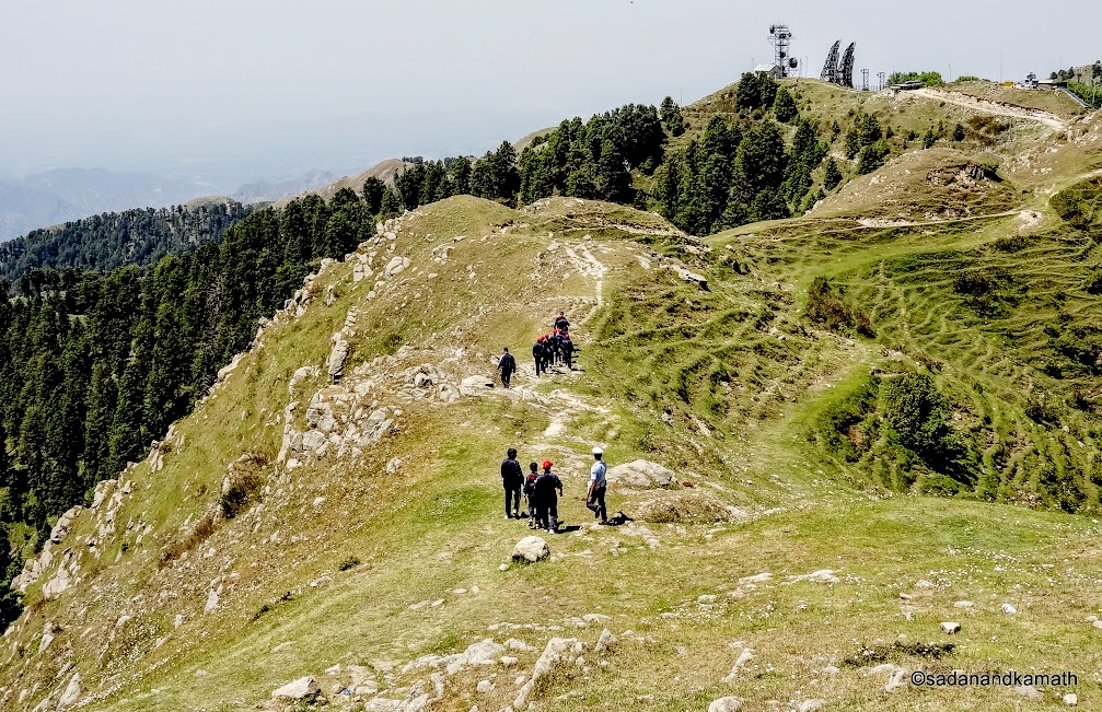
Looking back the trek path as we are close to the rest point.
Even though the weather was pleasant, the strong sun on a cloudless day made the walking a bit tough, that to on a climb. But the beautiful sceneries of valleys and the green forest in contrast with snow peaks of Pir Panjal range made us forget the minor agony of sun tan. While children and ladies in our family took rest for some time in the shaded rest point, myself and my son walked towards the valley side to have great views of the deep valley and did some photography. A group of Air Force Cadets were returning from Dainkund probably after their daily walking exercise.
A zoomed shot of one of the peaks of Pir Panjal range taken on way to the
rest point.
The valley side view from the Rest Point.

A few of the hikers can be seen on the top of a hillock to have a ring side view of the snow clad peaks of Pir Panjal range.
After resting for about 10 minutes at the rest point, we commenced our walk towards Paulhani Mata temple. From now onwards, the walk was easy as the climb was gradual. Also, there was no more concrete path as the it was more or less an even path except in a couple of places where small patches of climbs were followed by descends. Now, we were moving closer to a wider range of the Pir Panjal snow peaks. Also, there were meadows all along the path. So occasionally, we would see shepherds taking their livestock of cows, buffalo and goats to these meadows for grazing.

View of Kajjiar with lake from Dainkund trek.

Zoomed shot of one of the prominent peaks of Pir Panjal range.

A long shot of a panoramic view of Pir Panjal range.

Paulhani Mata temple which is actually located in a valley top (as against the mountain top) can be seen only when we were barely 200m from it. Until then, the temple was not visible from the trekking path.
We reached the Paulhani Mata temple complex at 11.45 a.m. There was a moderate crowd of tourists as well as locals from the adjoining villages. Paulhani Mata is said to be an incarnation of Kali Mata. The story goes that there was a kund ( pond) where dains (witches) used to visit and create problems for the villagers. Hence the name is Dainkund. Kali Mata in the guise of Paulhani Mata visited the place freed the pond from the witches. In honour of Kali Mata, villagers constructed a temple. Now the pond is located under the Air Force jurisdiction which is prohibited for the general public. The locals revere the Paulhani Mata and on all the important events in the family like birth, marriage and the important festivals, locals visit the temple to take the blessings of Paulhani Mata. The devotees present tridents to the deity on each visit.

View of snow clad Pir Panjal panorama from the temple complex.

Zoomed shot of Manimahesh Kailash peak from Temple.

Zoomed shot of some unidentified peaks of Pir Panjal range from the temple.

Zoomed Shot of an unidentified peak of Pir Panjal.
In the vicinity of the temple, there are a couple of eateries which provides tea, cold drinks and fast food for the devotees. Most of the visitors starts their return journey after visiting the temple. Many may be under the impression that the panoramic view of the snow clad mountains can be best seen from the backside of the temple complex. This is partly true as some part of the view on the left side gets blocked by a hill top. We decided to explore the hill top under the assumption that the snow peak view from the hill top would be better than that from the temple complex. We were not wrong. It was a ring side view of 360 degree - from snow clad Pir Panjal range to the plains of Punjab.

View of Paulhani Mata temple from the hill top.

A dog climbs on a hill top amidst the carpet of wildflowers ' to have 360 degree view of the Himalayas'.

We look so small in the backdrop of snow clad Pir Panjal range as we are about to reach the hill top.

At last on the top of a hill top with a meadow at about 3000m ( 10000ft.) above sea level.

A panoramic shot of snow clad Pir Panjal range from the hill top.
After spending about 30 minutes on the hill top to have 360 degree grand stand view of snow clad Pir Panjal range, we descended to the temple complex and commenced return journey at around 12.30 p.m. It took us hardly 30 minutes of non- stop walk to reach the Air Force Barrier where our car was parked. We proceeded by Car to Kalatop Sanctuary before returning to our Hotel at around 4.30 p.m.

Returning from Dainkund trek with resting point in the background.
The trek was most rewarding for all of us among all other sight-seeing points in around Dalhousie. The weather was right. The trek route was right for a family group including the children. Sceneries were breath-taking. The risk en route the trek was minimal. After observing the topography of the trek, my view is that Dainkund would be a great destination for a winter trek for those who needs to have some calculated adventure added to the trek.