Showing posts with label Kedarnath. Show all posts

Sunday, July 18, 2010

Trek to Kalimath, Kedarnath-Vasuki Tal, Tungnath-Chandrashila, October 1998


As I occasionally go through our somewhat faded pictures of our October 1998 trek, I ponder as to why we could not decide on any regular trekking destination and instead chose some assorted treks. A couple of possible reasons : First, we could not meet and decide on our trekking destination for 1998 probably due to some more pressing family commitments. Second, the August 1998 massive landslides – both in Garhwal and Kumaon may have put a dampener on our trekking plan. But the mountain bugs in each of us compelled to plan at least some short treks. With each of us having our own preferred short treks in mind, we decided to meet everyone’s aspirations by planning some short treks around Kedarnath route. This time, we did not draw a detailed itinerary of treks as we usually do but kept it flexible except that Mumbai-Delhi-Mumbai train tickets were booked with couple of extra days to take care of our flexible schedule..
I was keen on visiting Kalimath this time as in 1992, I had missed it while trekking to Madmaheshwar as part of our Panch-Kedar trek. The Head Priest of Ukhimath had then convinced me to trek to Ransi on way to Madmaheshwar via Mansuna as it was connected by a mud road where share-jeeps plied. Krishnamurthy was keen on Kedarnath as he had not yet visited the place. Jambukeswaran had no particular preference except that he was keen to visit the Himalaya. Deshpande could not join us for the trek for some personal reason and instead Jumbukeswaran’s office collegue ( co-incidentally he was also a Deshpande) joined us. It was his first trek.
On a warm and humid October night, we boarded Golden Temple Mail from Borivali and reached New Delhi the next day late evening. On the same night, we took Mussoorie Express which left about 2 hous late from Delhi Jn. We reached Haridwar at 8.30 a.m. A bus from the Haridwar station took us to Rishikesh in about an hour. We stayed at a hotel close to the GMOA bus station. An early morning GMOA bus to Gaurikund dropped us at Guptakashi around 12.00 noon. We checked into a newly opened Hotel Shubham Basera near the bus stand. Obviously, the room was neat; the bed sheets, pillows and blankets were fresh and the toilet was clean too and all these at good bargain price of Rs.200/- for a four-bedded room.

Guptakashi temple. Water flowing from Gaumukhs on either side of the platform is believed to be from Ganga and Yamuna rivers.

Guptakashi-Kalimath-Guptakashi (6+6 Kms trek)
After a light breakfast, we left our hotel room by 7.00 a.m. We had already decided that we would trek to Kalimath instead of taking share jeep. Incidentally, we did not find any jeep going to Kaliimath probably the road damaged by the massive landslides two months back was not yet ready for vehicular traffic. After descending from the road side, the trek was mostly through forest. After crossing a narrow iron bridge, we reached to a cluster of houses on an open place and at this point we witnessed the damages caused to almost all terraced farms which were totally covered with rocks and rubbles without leaving any trace of a farm land. It was unbelievable to see a big hillock sitting pretty on a farm which, at first, we thought that it was really a hill in its natural setting. It was only when a villager told us that the hillock had slid from the top during cloud burst and settled on this farm that we got to know of the reality.

Trekking route to Kalimath passes through forests.

At the starting point of the trekking path to Kalimath.

Me on a damaged bridge over a stream on to Kalimath.

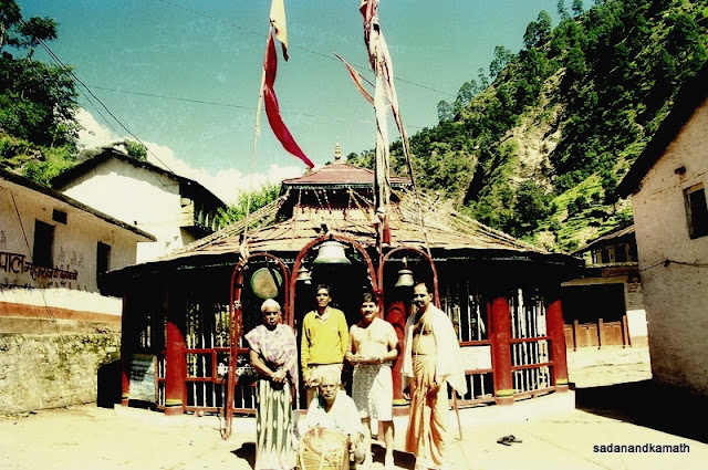
Since it was an easy walk, we could reach Kalimath village by 9.30 a.m. We went straight to the bank of Kaliganga. Though the water in the river was cold, the strong sun made the bath refreshing. After a few climbs, we reached the Kali temple. There were no visitors in the temple complex when we were there for about an hour or so. The priest did some pujas ( or some rituals?) for us. The Kali temple did not have any idol but Kali in the form of a Yantra was worshipped. On either sides of the Kali temple were Laxmi and Sarswati temples. It was amazing to note that while we had witnessed the extensive damages in areas very close to Kalimath, the temple complex was spared from the damages except a partly collapsed residential house.


Kalimath village on the bank of Kali Ganga river. In the background is Kedarnath peak (faintly visible).

Kali temple complex. The temple complex was saved from a series of massive landslides in Kalimath-Kotma areas, about two months before our visit. A part of a house on the left was, however, destroyed by the landslides.


We left Kalimath at 12.00 noon. While passing through the same open place where landslides had inflicted maximum damages to farm land, a villager came running and told us of his woes about his farm being destroyed by landslides and his banker, State Bank of India at Guptkashi insisting on repayment of loan instalments. It appeared to me that he had taken a short term loan for raising rainy season crops and the loan was to be repaid after harvesting the crops. Since his entire crops were damaged and he was not in position to repay the loan, he was in a quandary as to how he could come out of this situation. Furthermore, he was not in a position to raise winter crops and repay loan though belated as his farm was damaged beyond redemption. From what I could also guess from his talk, he seemed to be disturbed by the frequent visits by the bank official to his house for recovery of the loan.

Kali temple complex seen from Ransi road. In the foreground is Kali Ganga river.

A school around Kali temple complex.

Kali temple.


After listening to his predicament, I suggested him to write a letter to the branch manager giving the circumstances under which he was not in a position to repay the loan in time and request him to convert his short-term loan to medium term loan as has been practice when there is a natural calamity such as drought or flood. As none of us carried any blank paper or note book, the poor farmer had to rush back to his house and bring the paper to write the application. I wrote the application for him on the lines suggested to him earlier and told him to sign the application and give it to SBI after taking a copy of the same. I hoped that the SBI branch manager would not create any further problem for this farmer after submission of application it was a reasonable request. But I was really dismayed by the branch manager’s attitude toward this farmer in the background of a natural calamity. In fact, he should have proactively guided this farmer about the alternative options. Most of the small farmers are simple and honest and in normal circumstances, they will be eager to repay the loan as early as possible as they feel that their honour in the society is at stake when the bank official visits their house for recovery of loans.

Ukhimath temple complex.


We reached Guptkashi around 3.00 p.m. as almost one hour was taken for dealing with the farmer’s problem. After taking a tea break at the bus stand, we took a share jeep for a 14 kms drive to Ukhimath as Krishnamurthy was keen to visit the temple. We return to Guptkashi by evening. After fixing with the share jeep for the next day’s early morning journey to Gaurikund, we returned to our hotel.

Kedarnath temple.

We stayed for two days at Maharashtra Mandal in Kedarnath.


Guptkashi-Gauikund-Kedarnath ( 31 kms by share jeep and 14 kms by trek)
The share jeep left at 5.30 a.m. and reached Gaurikund at 7.00 a.m. After a hurried breakfast, we commenced trekking to Kedarnath. There were not many pilgrims on the route so the mule nuisance was minimal. The weather was pleasant throughout the trek. After a lunch break at Rambara, we reached Kedarnath at 2.00 p.m. We got accommodation at Maharashtra Mandal. I had stayed here on two earlier occasions.
The Maharashtra Mandal guest house was planned by one Karnataki ( surname in Maharashtra though surname gives an impression that the person is from Karanatak) a businessman from Yeola ( Nashik district) when he first visited Kedarnath in early 1900 when he noticed that there were not many shelters for pilgrims. Later, he set up a make-shift house to accommodate pilgrims. Over a period of time, the NextGen of Karanataki family who had made Guptakashi as their permanent residence, improved the quality of accommodation which was possible by donations received, mostly from Maharashtra. When I last stayed in September 1999, it was managed by 3rd generation Karnataki brothers who were finding difficult to speak Marathi.
We could see from our room the path to Vasuki Tal. With our flexible schedule, this was our chance to do this trek as it has been eluding me despite the fact that this was my fourth trip to Kedarnath. When I talked to Satish Karantaki of Maharashtra Mandal about the feasibility of doing a day trek to Vasuki Tal the next day, he said that it was possible to this trek in a day to return to Kedarnath. He then arranged a guide for us. Satisfied with this development, we went out for a stroll around Kedarnath. As we were near the temple, a light shower with strong cold breeze forced us to take a shelter in a shop just adjunct to the temple complex. It was after a while when we decided to rush to temple as it was getting dark. There was not much rush inside the temple and we could sit very close to the ling for sometime. Krishnamurthy was overwhelmed by such a nice darshan of Kedarnath.
On to Vasuki Tal. After a steep climb across Mandakini river, some rest on the top. Kedarnath peak and Kedar Dome in the background.

Rustic landscape on way to Vasuki Tal.

After a short easy walk, the path became stony as can be seen on the curve.

Kedarnath-Vasuki Tal-Kedarnath (6+6 kms)
We had a quick breakfast at a make-shift dabha in front of Maharashtra Mandal and had also arranged for pack lunch of alu paratha from the same place. It was 7.30 a.m., when we left the place for Vasuki Tal. After crossing river Mandakini, we were on a steep climb of about 1 km after which we reached on a hill top. From here, we get good views of Kedarnath temple below and peaks around the temple. From here onwards, the landscape changes from greenery to barren mountains with stones and rocks strewn all over the place. It was in this context that a guide was necessary as at many places there was no way to know where the path will lead.. The rocky and boulder ridden path with climbs and descents with lack of oxygen on such a high altitude made the progress very slow as we had to take frequent rests. The last one km to the lake was a steep descent in a relatively better path.

Some rest on the rocky climbs.

Way down to Vasuki Tal.

Some isolated patches of snow as we descent to Vasuki Tal.

At last emerald green Vasuki Tal.

We with Vasuki Tal in the background.


The emerald green Vasuki Tal lies as a bowl surrounded by stone-filled banks with snow-clad mountains as backdrop. But clouds and mists deprived us of the pleasure of enjoying what could be beautiful scenery. We spent about 30 minutes near the lake. After finishing our packed lunch, we started the return trek at 1.30 p.m. by which time the weather had turned cloudy. Luckily, it did not rain as we reached Kedarnath by 5.30 p.m.
Kedarnath-Gaurikund-Guptakashi (14kms by trek, 31 kms by share jeep)
We started leisurely from Kedarnath at 10.15 a.m. reached Gaurikund comfortably by 3.00 p.m. After taking a lunch break, we got a share jeep for Guptkashi. With previous day’s tough trek still giving some discomfort, it was decided to take rest at our familiar hotel at Guptkashi instead of moving to Chopta, our next destination.

Guptakashi-Chopta-Tungnath-Chandrashila-Chopta (44 kms by bus, 5+5 kms by trek)
We got 6.45 a.m. Bhookh Hartal bus at Guptkashi and reached Chopta at 9.15 a.m. After taking breakfast at a dabha located at the starting point of Tungnath trek, we proceeded for Tungnath. After a gradual climb on a stone-paved path, the climb became steeper. On the right side of the slope was Chopta bugyal with some shepherds’ huts. Other than handful of pilgrims, the trek path was almost deserted. We reached Tungnath at 12.00 noon. By this time, the clouds and mists had already covered the peaks.
Chopta bugyal on way to Tungnath.

Shepherds' huts at Chopta bugyal.

Climb to Tungnath.

Tea break on way to Tungnath.

A research centre seen from Tungnath.

Tungnath temple.

Stone idol of Ganesh outside Tungnath temple.

Tungnath temple viewed from an adjoining hillock.

After taking a round of the temple, we met a Sadhu who was resting in an open place in the sun near the priest’s residence. He stayed in a cave about one km from the temple. When I asked him as to how he managed to stay in a extreme winter, expecting that he would give me the familiar reply of sadhus’ control over their nerves and senses, I was pleasantly surprised to get a rationale answer to my query. He said that the slope above the cave’s entrance was very steep making it impossible for snow to get accumulated. The South facing entrance in winter will ensure that during sunny days, sun rays will fall on the cave almost throughout the day due to sun moving in southern solstice, making the cave relatively warm.
A Sadhu in pranayam pose. He said that he stayed around Tungnath temple all through the year.

On the Chandrashila peak.

Weather turned foggy and windy when we started return journey from Chandrashila.

Tungnath temple seen from the way to Chandrashila peak.

As we proceeded to Chandrashila peak, there was a light drizzle on the way but it was manageable. There were some scary moments when thick mist covered the trek path making it invisible. At the peak, there was a small stone temple which acted as the final point on Chandrashila peak. It was apparent from the beginning itself that we would not be able to get any view of the peaks as they were already covered by clouds. We returned to Chopta via Tungnath by 4.30 p.m. We stayed in a dabha for the night.


Chopta bugyal.

GMVN Rest House, Chopta with peaks in the background. At left is Ukhimath-Gopeshwar Road.

Peak view from Chopta.

Chopta-Joshimath (90 kms by bus)
We were to get the same Bhookh Hartal bus to Joshimath which dropped us at Chopta the previous day. We could see the bus coming from Kund about 30 minutes before it reached Chopta at 9.30 a.m. Being the only bus connecting Gaurikund with Badrinath on Ukhimath-Chamoli road, this bus was full of mostly local villagers to whom this bus was a lifeline. So we had to travel standing up to Gopeshwar after which we got the seats. The bus reached Joshimath at 3.30 p.m. We stayed in GMVN.
Joshimath-Auli-Joshimath (14 kms by share jeep, returned by trek, 6 kms)
Although, I had passed through Joshimath four times for Badrinath, I had never been to Auli. In fact none of us had ever visited Auli. With our flexible schedule, it was possible to fit in Auli while going to Badrinath. We got a share jeep at 8.30 a.m. for Auli and reached Auli at 9.30 a.m. We got into a Cable Chair Car and got down at Tower No.8 for grand views of peaks such as Hathi, Ghori, Nanda Devi, Dunagiri, Trishul. We walked on a vast expanse of bugyal which within a couple of months would turn into one of a skiing slope. We ended our walk at a place from where the trek to Gorson started. On our return to the road head at Auli, we visited an impressive looking Hanuman temple located on a small hillock.

Chairlift for Tower-10 in Auli.

Cows grazing in Auli bugyal with Himalayan peaks in the background.

Ghori and Hathi parvats seen from Auli.

Nanda Devi from Auli.

From left to right : Dunagiri, Nanda Devi and Trishul.

Nanda Devi and Trishul from Auli.

After a light refreshment at the GMVN restaurant, we came to the road for trying our luck in getting a share jeep to Joshimath. On a second thought, we decided to trek down to Joshimath as we were not sure of getting share jeep. We got down from the road and walked through the forest. Thereafter it was downhill cutting across Auli-Joshimath road at many places. The last one km was a descent through cemented path which ended at Malari end of Joshimath. It took us one hour to reach Joshimath from Auli – the same time which the share jeep took to drop us to Auli from Joshimath. In the evening, we visited Jyothirmath and Narsinha Temple Complex.


A priest inside Hanuman temple, Auli.

Auli bugyal with Hathi and Ghori parvats in the background.

GMVN, Auli.

Our trip concluded with a visit to Badrinath the next day.

*********

Sunday, May 24, 2009

Trek to Valley of Flowers, Hemkund & Kedarnath : August 1990

Impossible to take a step without crushing flowers. This observation by Frank Smythe, who accidentally discovered the Valley of Flowers (VOF) in 1931, was enough for me to plan a trek to VOF in August 1990 with Jambukewaran and Deshpande, my office colleagues. Those days, GMVN brochure was the main source of information about the details of the VOF trek. The idea of trekking VOF in monsoon season was somewhat not appealing but that was the best season to see flowers in VOF [ mid-July to mid-August]. We reached Haridwar via Delhi from Mumbai and stayed overnight [Samrat Hotel @110/-].
Day-1 : Haridwar-Joshimath (280 kms)
We commenced our road journey from Haridwar at 8.00 in the morning by a hired Maruti van. Although it was almost a rain-less day, we encountered first landslide near Byasi on way to Devprayag. After about an hour or so, the debris were cleared and traffic resumed. The next landslide was somewhere between Pipalkoti and Joshimath resulting in the partial road block and slow movement of traffic to and fro Joshimath. We reached Joshimath at around 6.00 p.m. by which time the last gate for the road beyond Joshimath was closed for the day. We had to stay overnight at Joshimath [Kamet Hotel @70/-].
Day-2 : Joshimath-Govindghat-Ghangaria [20 kms by road and 14 kms by trek]
We took the first gate at 6.30 in the morning from Joshimath for Govindghat in the cloudy weather. After reaching Govindghat, we descended by a side path for about 500m and after crossing the suspension bridge over Alaknanda river, we reached near Gurdwara. After depositing our non-essential luggage at one of the shops in the vicinity of Gurdwara and buying ponchos, we commenced 14 kms trek to Ghangaria.
Govindghat
Beginning of trekking to Ghangaria
A group of sikh pilgrims on way to Ghangaria

The mule track was all along Lakshaman Ganga stream which eventually meets Alaknanda river. After about 3 kms, we reached Pulna, a small hamlet where many pilgrims stopped for a while for rest. At this point, it started raining which became heavy as we proceeded towards Bhyundar. The rainwater flowing across the mule track made our progress slow. The water level of the Lakshaman Ganga stream had already started rising and at some places it was close to the trekking path. There were many waterfalls on the way, a couple of them being the large ones. By the time we reached Bhyundar, we were completely drenched even with our ponchos on. The rains and the cold weather made us shiver as we stopped at Bhyundar for rest. After a cup of hot tea, we decided to move ahead as walking was a better option in cold weather than taking rest.

Waterfall somewhere between Pulna and Bhyundar

A swollen stream very close to the trekking path towards Bhyundar

The torrential rain continued to lash as we commenced our final lap of the day's trek to Ghangaria. The overhang of clouds with heavy rains deprived us of any scenery on the way. The steep climb under heavy rains made our progress very slow. We reached Ghangaria ( 3050m) by 4.30 p.m. Fortunately rains had abated but the weather was still cloudy and cold. Without doing much scouting, we took a room at Hemkund Lodge [@60/-]. After dumping our luggage, we spent the rest of the day sitting near the cooking place of the lodge to get our wet cloth dry. We left the place only after dinner and retired to our room quite early.

Day-3 : Ghangaria-Valley of Flowers-Ghangaria (5+5 kms trek]

After the breakfast of Alu Parathas and tea, we started our trek for VOF around 7.30 in the morning in cloudy weather. After paying the entry fee (Rs.2/- per head + Rs.2/- per camera), a short walk led us to a point where the Forest Department's board indicated the direction to the left for VOF and the right to Hemkund Saheb. The first 2 kms of trek was paved alongside the Pushpavati stream which flows from VOF.

On way to Valley of Flowers from Ghangaria

A make-shift wooden bridge over Pushpavati stream

As we moved further, we came across the first broken glacier over the trekking path which was not difficult to negotiate. However, the subsequent two glaciers which we came across were large ones completely covering our trekking path. Fortunately, PWD workers had already made steps and the sticks which we were carrying come handy in negotiating the snow path without much difficulties. As we were at the end of our snow walk, the valley became visible between two mountains which become clearer as we moved ahead. The valley looked beautiful with carpet of plants with flowers surrounded by meadows with snow-caped peaks visible at the far end.

Encountering first snow on way to Valley of Flowers

Walking over snow towards the valley


Cloud formation over Valley
The valley opening between two mountains
It was around 11.30 a.m. as we entered the valley. The weather was cloudy with occasional light rains. It was a mesmerising feeling for us to walk in the midst of green carpets with long stretches of wild flowers plants as far as my eye could see. Many of the flower plants were as high as 6-7 feet. The observation of Frank Smythe was, however, no longer valid after 60 years as a narrow path made by a steady flow of trekkers existed. [ I understand that forest authorities have paved this path with stones]. Nevertheless, in many places, it was impossible to avoid brushing with plants and flowers while walking in the valley. In some places, we had to physically push these plants sideways to walk further.


First encounter with mass flowering as we entered the valley

The valley of green carpet with wild flowers


Wild flowers-1
Wild flowers -2
Wild flower-3


Wild flowers-4
We saw varieties of wild flowers many of which I had not seen in any of my earlier visits to Himalaya. It was a visual treat for all of us to see from an higher elevation the light breeze swinging the flowering plants giving an impression of a multi-coloured carpet being laid in the valley. We were surprised that compared to the pilgrims crowd at Ghangaria, there were not more than 8-10 trekkers in VOF including our group to see the nature's spectacles. One of the members of other group was heard complaining to their Leader in Marathi. " Have you brought me here all the way from Mumbai just to see therda chi phula ( Impatiens flowers) which I could have seen in Borivali National Park in rainy season?" Each person has his own perspective of looking at the nature. The pilgrims were here mainly to complete their visits to Hemkund Saheb. Additionally, they would rather make a visit to Badrinath than 'wasting' one day in VOF for seeing some jungli phuls (wild flowers).

Me, Deshpande and Jumbukeswaran in VOF


Wild flowers-5

Wild flowers-6
The most common wild flower in VOF

Multi-coloured wild flowers

We had already spent about an hour in the valley and still there were miles to go where we could see the stretches of wild flower plants merging with meadows all around. The the constant cloud movements, however, eclipsed the view the snow covered peaks. Since the muddy path was already water-logged and it was raining a bit, we decided to return. We reached Ghangaria by 2.00 p.m in a cold and cloudy conditions. We had our lunch at one of the dabhas and rest of the day was spent mostly in the same dabha to get some warmth from the cooking place with several rounds of tea and assorted pakodas to justify our sitting in the dabha for long time. We also visited the Gurdwara just to enquire about the possibility of getting a better room for the stay but a large pilgrim crowd taking shelters in the Gurdwara premises was good signal that rooms were full.

Day-4 : Ghangaria-Hemkund Saheb-Ghangaria (6+6 kms trek)

After the usual breakfast of parathas , we left Ghangaria at around 6.45 a.m. for Hemkund Saheb in a sunny but cold morning. After about 200-300 meters walk from Ghangaria, a stony path to the right goes to Hemkund (6 kms). After initial plain walk on the stone-paved path, we came across a large glacier which was broken into two parts, the dividing line being the stone-paved path. We saw a few buffalow grazing on the broken glacier which had slided through the slopes and settled in the valley. Perhaps some small patches of grass must have grown through the thin snow layers.

Ghangaria seen from trekking path to Hemkund

Trekking junction - left to VOF and right to Hemkund Photo by Deshpande

On way to Hemkund by the side of a broken glacier

After crossing the glacier, the climb became steeper which was obvious as we were to gain altitude by more about 1300m in a 6 kms trek. The steep climb forced us to take rest quite often to regain our normal breathing. Even the mules carrying pilgrims and other supplies were breathing fast as seen from the foam accumulated around their nostrils. On this stretch also, we came across some of the wild-flowers we saw in VOF. As we gained altitude, the wild flowers were replaced by a series of brahm kamal plants. As we were close to our destination, the weather turned cloudy and in some places we were virtually walking in cloud and mist making our progress slow. Fortunately, it did not rain much. We reached Hemkund at around 11.00 a.m. At first, the constant movement of cloud and mist around the lake did not give us any idea of the topography of the area. After taking a quick dip in the ice-cold water of the lake, we took a round of the lake starting with Lakshaman (Lokpal) temple and ending with a visit to Gurudwara with star-shaped roof which was under renovation .

Other part of the broken glacier lying in the valley on way to Hemkund
Pilgrims resting on way to Hemkund

Trekking through the mist on way to Hemkund

There was a brief lull in the cloud movement mist which gave us an opportunity to see the Hemkund Saheb in good perspective. The lake was surrounded by snow-covered mountains with scree and boulders lying at thier slopes. The Gurdwara was located at the shore of the lake. The sad part was that the film in my camera got over. I cursed myself for inadvertantly leaving the extra film rolls at Govindghat.

There were some places around Hemkund which could have been explored by us such as walks to the nearest bases of snow-clad mountains. But at high altitudes, the psychology of most of trekkers, who had just a couple of trekking experiences like us, would be to leave the place as early as possible when the weather was fine. So without exploring any nearby places, we started our return trek around 12.30 in the afternoon and reached Ghangaria by 3.00 p.m. without facing any rain on the way. As in the previous days, the rest of the day was spent in the dabha for lunch, tea, more tea and pakodas and ended with dinner.

A hidden waterfall on way to Hemkund

Wild flower on Hemkund route

Wild flower on Hemkund route
Day-5 : Ghangaria-Govindghat [14kms- trek] Govindghat-Badrinath-Pipalkoti [120 kms - car]

We commenced our trek back to Govindghat at 7.00 in the morning. The plan was to drive from Govindghat to Badrinath for an overnight stay and trek to Mana-Vasudhara falls. We reached Govindghat by 11.00 a.m. After collecting our luggage, we drove to towards Badrinath. As we were just short of 3 kms from Badrinath, we came across a huge water fall which was cascading from the top of the mountain with a great force crossing the road with full force. Our driver, after seeing the force of the water, decided that it was dangerous to drive through the waterfall as the light vehicles like Maruti van may be thrown in to the valley by the sheer force of the waterfall. Even Ambassdor car drivers refused to cross the waterfall and went back. After pondering over the options of going back to Joshimath or crossing the waterfall and walk the remaining 3 kms of distance to Badrinath, we decided to go for the latter option taking only one pair of toursers leaving the rest of our luggage in the van. It would not have been possible for us to cross but for the support of the locals who took us one by one from the cliff side of the road in swift movements allowing bare minimum time to take support of our legs through the water.

We reached Badrinath by walking 3 kms on the road. After a much needed bath in the hot spring, we took the darshan of Badrinath which was all for oursleves. The priests advised us to stay overnight to witness the religious ceremony of Krishna Jnamashtmi ( birth day of Lord Krishna). We could not do so as we were eager to come out of the treacherous waterfall before further rains make it impossible to cross. After spending about an hour or so, we walked down up to waterfalls. Fortunately, we were lucky as we boarded a GMOU bus coming from Badrinath side as it reached the waterfall point and got down on the other side of the waterfall where our driver was waiting for us. We stayed overnight at Pipalkoti [Atul Hotel @60/-]. Since we had now 3 extra days, we decided to visit Kedarnath, the first visit by all of us to one of the chardhams.
Day-6 : Pipalkoti - Gaurikund [155 kms]
After the breakfast of idlis and dosas at a restaurants near bus stand, we started for our next destination Gaurikund at 8.00 in the morning. The rains had made the drive to Gaurikund via Rudraprayag scenic with Alaknanda river in full force. The cloud and mist in the valley did not give us the chance to view the mountains. We reached Gaurikund at around 2.oo p.m and stayed overnight. [Annapurna Lodge @45/-].

Paddy fields on the bank of Alaknanda river somewhere between Pipalkoti and Rudraprayag
Day-7 : Gaurikund-Kedarnath [14 kms trek]
We got up early in the morning and had a bath in the hot springs located very near to our place of stay. After the breakfast of Alu Paratha, we commenced for trek for Kedarnath around 6.00 in the cloudy morning. Up to Rambara, the trek was a gradual climb, mostly in a slushy path. Being rainy season, there were not much of a pilgrim traffic. Just before Rambara, the muddy path came close to a roaring Mandakini river. After crossing a wooden bridge, we reached Rambara. We took some rest as here onwards, it was a steep climb upto Garud Chatti.
Mandakini in spate near Rambara

Since we had already done trek to VOF and Hemkund Saheb, we were well acclimatised to this part of the steep climb. After Garud Chatti, it was about 2 kms, more or less, of a plain walk up to Kedarnath. Having done this trek 5 times so far, I can say that psychologically, this is the most difficult part of the trek/piligrimage as after having done about 5 kms of a steep climb from Rambara, Kedarnath temple looks so near but it was too far to reach. This is also the place where many pilgrims get breathing problem despite walking on a plain path as they are at an altitude of about 12000 feet. But for nature lover, all pains and fatigue are soon forgotten when they encounter the grassy patches full of wild flowers , especially in rainy season, on both sides of the path with a soft sound of gushhing water of Mandakini river .

Zig-zag trekking path to Kedarnath from Rambara
Wild flowers on the way about 2 kms before Kedarnath


 Kedarnath temple complex in the shadow of cloud-covered Kedar dome 


Kedarnath temple
We reached Kedarnath at around 12 noon. After checking in Himlok Hotel [@60/-],
we had an 'exclusive' darshan at Kedarnath temple since there was not a single pilgrim inside the temple. This encouraged Jambukeswaran to go for some special puja. After taking the receipt for the said puja, we again went inside the temple, sat in front of the hump-shaped shivling, chanted the mantras with priest and bathe the shivling with water, milk and ghee. It took about half an hour to cokmplete the ceremony.

Kedarnath temple seen from the backside

Kedar dome forms the background to the Kedarnath temple
Day-8 : Kedarnath-Gaurikund [14kms trek]-Haridwar [234 kms]

We started from Kedarnath around 8.00 a.m. in ther sunny morning. As we walked towards Garud Chatti, the Kedarnath peak which had so far elluded us due to cloudy weather was now visible. After a short stop at Rambara, we reached Gaurikund at 12 noon. After locating our driver near the bus stand ( there was no cell phones those days) we commenced our last lap of journey to Haridwar which was smooth. We reached Haridwar by 7.00 p.m. We returned to Mumbai after taking a day's halt at Delhi.

Meadow on the other side of Mandakini near Kedarnath
Pilgrims returning from Kedarnath going towards Garud Chatti
Terrace farms seen somewhere between Kund and Rudraprayag

Photos by the author