Friday, December 11, 2015

Queenstown - The Adventure Capital of New Zealand : Part-2


 Day-3 : To Khawarau - Arrow Town
Today was a leisurely day as we were scheduled to visit Khawarau bungy jumping and other adventure sport activities, where we would be the spectators for the adventure sports activities rather than the participants. Thereafter we planned to visit Arrow Town museum. The afternoon was kept as a rest time which meant shopping in Queenstown.

We left hotel at around 10.00 a.m. and reached Khawarau bridge in an hour or so. From the observation platform, we saw few youngsters attempting bungy jumping. On the other side was youngsters as well as elderly tourists attempting zip rides. This gave us some motivation to try at least zip rides. Zip rides cost NZ$30 per person and we had to sign an undertaking that we do not suffer from heart problem, back ache and spondylitis. We sat on a zip chair with multiple hooks attached to our waist belt. After 'get, set. ready' call, we zipped down on a cable with a great speed and stopped abruptly just before the end of the rope. After a wait of a minute or so when we were swinging in our chairs, the direction of the ride was automatically reversed.  Now it was time to zip up at a lower speed. We reached the platform and got unhooked. Overall, it was a thrilling experience. 

We left Khawarau for Arrow Town at around noon for visit to Lakes District Museum. There was not much to talk about the museum but the Arrow Town itself appeared quite distinct from other towns we have seen in New Zealand. It looked more like villages in Swiss Alps on Interlaken-Lucerne route. There was some thing different in the architecture of houses here. Even Post Office looks like an heritage house.

We returned to Queenstown in the early afternoon. We had lunch in an Indian restaurant called 'Spice Room'.  Rest of the afternoon was spent in strolling in town centre and doing some shopping. At around 6.00 p.m., we reached out hotel  as we had to pack our baggage for checking out from the hotel the next day early morning.
Road bridge over Khawarau river seen from Bungy Jumping point.

Bungy Jumping point. A girl is getting ready to jump.

A man is suspended over Khawarau river after the bungy jump

The man is being picked up by the crew on the boat.

Tourists on Zip ride over Khawarau river.

View from the bus on way to Arrow Town.


The gold dust collected from a river on display in Arrow Town Museum. Gold mining from the rivers in New Zealand is now banned.

An old piano on display in Arrow Town Museum

An old clock on display in Arrow Town

An old accordion on display in Arrow Town Museum

Arrow Town Post Office just opposite the Museum.

The bird looks like house sparrow but it is not. The bird is called Chaffinch. It is a common sight to see this bird in Queenstown's gardens.


Day-4 : To Wanaka-Fox Glacier
We checked out from the hotel at around 9.00 a.m. and departed for our first destination, Wanaka by bus. The weather was great with blue sky. Our first halt was at Puzzling World, a  house of puzzles. In this house, everything looks puzzling and we try to get scientific answers as to why things are happening weirdly. In fact, most of the things that appears puzzling are optical illusions created by the structure of the house and lay out of the rooms. For example, in a room, we were walking on a 'oscillating' floor by which we were losing balance. So we had to walk holding each others hands. But  I could walk alone slowly without any support with the eyes closed.

Screen shot of google map showing the direction, Queenstown-Wanaka-Fox Glacier.


From Puzzling World, it was a short distance to reach Wanaka town which is at the shore of Wanaka Lake. We got a photo shooting break of 10 minutes on the shore of the Wanaka Lake. Since the sky was, more or  less, clear, we could see snow-clad mountain at the far end of the lake. It is a glacial lake fed by the melting snow from the peaks located in the north side. 

We had lunch in Wanaka town  in an Indian restaurant, 'Spice Room'. Is it not surprising that a town with a permanent population of around 7000, boasts of having an Indian (read Punjabi) restaurant.

The next stage of our bus journey was going to be of 4 hours on a hill road. As is the convention which we have observed in regard to bus journey, the driver would invariably stop the bus every two hours for tourists to visit rest room and if time permits, have a cup of coffee. The rest stop was as anticipated. After about 2 hours of drive, he stopped the bus at Hasat Visitors Centre for wash room break. Hasat is a very small town. In fact, by Indian standard of population, it will be called a hamlet.


From Hasat, the drive was very close to the Tasman Sea shore. The drive was scenic in that on the left side, we had Tasman sea shore, on the right was rain forests with high mountains - something which reminded me of driving in some parts of  Konkan area of Maharashtra  in rainy season. We were just a few kms from Hasat that the weather turned foggy (or misty?). For about 30 minutes, our journey was through fog/mist. The longer day time light facilitated risk free drive as the visibility was not much affected. However, with foggy weather, we  missed a lot of photo opportunities. There were hundreds of water falls on the way joining the streams. By the time, we reached Fox Glacier town around 6.00 p.m., light rains had started and the clouds fully covered the mountains in the vicinity of the town. 


Due to late sunset in the region, our planned schedule was to visit the Fox Glacier first and check in Heartland Hotel on return. But with cloud covering the glacier, there was no point in visiting the Fox Glacier now. It was, therefore, decided to make an attempt to reach the glacier the next day early morning.

We checked in the hotel at 6.30 p.m.  There was no Indian restaurant in Fox Glacier town. So we took continental sit-in dinner in the hotel's restaurant with 4-course menu. Since we men folk enjoy the continental preparation, we were happy for a change. But women-folks. specially vegetarian were not so happy with the main course though they like soup and cheese cake.

Wine yard on way to Wanaka.

View from the bus on way to Wanaka

The house of puzzling world, Wanaka.

Water flows from a giant tap? No, actually water sprinkles through fibre glass pipe.

Wanaka Lake with snow clad mountains in the background.

View from bus of Wanaka Lake.

Zoomed shot of an unidentified snow peak on way to Hasat

Wanaka Lake with snow clad mountain. Photo taken through the window of the bank.

Zoomed shot of an unidentified snow peak on way to Hasat.

Hasat Visitors Centre, a Rest Room stop.

The main street of Fox Glacier Town. On the left is Heartland Hotel where we stayed overnight.


Smoked Salmon with mashed potatoes with Tartar sauce for dinner.


Day-5 : Fox/Josef Glaciers-Greymouth
As we had to postpone the visit to Fox Glacier last evening due to bad weather, it meant that we will have to make up for the lost time by getting up early morning. So, after an early breakfast, we checked out of the hotel at 7.00 p.m. and drove a short distance of about 2 kms from the hotel to reach the gate to the walking tour of Fox Glacier which was about one hour's walk to the tail of the glacier. However when we reached the gate, the authorities had put the notice that due to bad weather at the glacier, no one was permitted beyond the gate. So, we had to be satisfied with watching the glacier from a distance.

The Coach Captain and Guide (in New Zealand, bus drivers are called Coach Captain) took us to Josef Glacier, about 25 kms north of Fox Glacier. From the road end, it is about a hour's  walk to the glacier. However, due to paucity of time at our end ( we had to catch 1.45 p.m. TranzAlpine train at Greymouth to Christchurch), the walk was restricted to 45 minutes. The glacier was covered in the cloud . Luckily, when we were about to return, we could see the glacier as the 'veil' of cloud got removed  over the glacier with a gentle breeze.

The dirt road to reach the walking point (foreground) for Fox Glacier. On the left his stream flowing from melting glacier which is grey. On the right is stream formed for rain water which is light blue.

Zoomed shot of Fox Glacier. It is rare sight to get the picture of glacier with a tree. For glaciers are normally located above the tree line.

Walking towards Josef Glacier, about 25 kms north of Fox Glacier.

Waterfalls on way to Josef Glacier.

Fully oxidised stones in orange colour beautifully contrast with green moss on way to Josef  Glacier

Zoomed shot of Josef Glacier.


The main features of Fox and Joseph Glaciers are that (1) they are the only glaciers in the world which are easily reachable from the road end with 2-3 kms of distance and (2) they are the only glaciers in the world which end in rain forest. The reason is that two glaciers are located in less then 3000m of height from sea level.


From Josef glacier, a drive of about 3 hours 30 minutes brought us to Greymouth railway station. 


Thursday, December 10, 2015

Queenstown - The Adventure Capital of New Zealand : Part-1

We were to spend 4 nights in Queenstown. Although the itinerary had indicated that we will be busy all the 4 days including half-a-day reserved for shopping, I was a bit sceptic because some of the activities were associated with adventure sports - bungy jumping, zip rides, speed boat rides with 360 degree spins,  para-sailing etc. We were all senior citizens (above 60 years). Therefore, we were not very sure as to whether we will be able to undertake or  permitted to do these activities. Anyway, we thought, as they say, we will cross the bridge when we come to it.


The shape of the things to expect in Queenstown become clear when  Air New Zealand's flight NZ.625 from Auckland was flying over Southern Alps. As the cabin crew announced the  flight getting ready for landing, there was no clue as to where the airport was located as the approach for landing was through the valley surrounded by mountains on both the side. The flight landed in Queenstown around 5.00 p.m. and within 20 minutes, we were in Mercure Resorts where we were to spend 4 nights in the company of Wakatipu Lake. We had dinner at one of the Indian hotels in the downtown.

Picture taken from the flight when it was over Southern Alps.


Mercure Resorts, Queenstown where we stayed for 4 nights.

Day-1 Cruise in Wakatipu Lake, Speed Boat Rides, Skyline on Bob Peak.
1. Catamaran Cruise in Wakatipu Lake
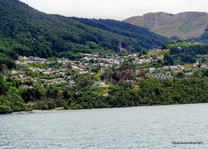
If one wants to know the topography of Wakatipu Lake, cruise on this lake is a 'must do' activity. We were booked on Southern Discoveries' 'Spirit of Queenstown' for 9.00 a.m. cruise. The weather was cloudy with intermittent light rains and appearance of sun. The Southern Alp region is known for windy weather. Luckily for us, the wind was moderate on the day of our cruise. The boat had open upper deck for 360 degree view and photography. We first sat in the cabin with comfortable chairs and large glass windows to avoid the cold breeze. However, we found that the real thrill of the cruise was on the open upper deck. I was on the upper deck for most of the time for the photography. The total duration of the cruise is 1 hour 45 minutes.

The captain of the catamaran was giving a running commentary about the lake as well as some important landmarks. He was friendly and talking to the tourists who visited him in his room. He even allowed some tourists including me to sit on his chair in the wheel house, donning his cap and to take the photograph. The lake cruise is the good way of getting a general perspective of Queenstown, the mountain ranges and the vastness of the lake itself.
Queenstown seen from the catamaran. The boarding point was on the left between a boat and the steamer.


Me on the catamaran cruise in Wakatipu Lake.


Mountain ranges partly covered in the mist.


View from the backside of catamaran.


View of Queenstown on return cruise.


A black beak Gull at the shore of Wakatipu lake.

2.KJet Speed Boat Ride
Our next schedule was KJet Speed Boat ride of about one hour. We were booked for 11.30 a.m. ride. So we had about 30 minutes to stroll on the shore of the lake. There were hawkers selling jewelleries made from jade and also the woollen caps, jackets and sweaters. We did not buy anything from here as we were to go for shopping in the evening. Our Speed Boat ride was delayed by 30 minutes as the boat had not returned from the previous ride on time.


There is some restriction on  KJet Speed Boat ride. Persons with blood pressure, heart problems, back ache and spondylitis are not permitted to take the ride as the boat races at the maximum speed of 85 kms per hours. At times, the ride is bumpy. And there are spins and twists of 360 degree even at this speed. So one has to constantly hold two handles in front of the seat. This meant that one can not take picture from the Speed Boat though the cameras are allowed with a warning that it may slip from the hand because of the speed and bumps. The boat can ride at its maximum speed even in the shallow water. The life jacket and water-proof jacket are provided by KJet.


We boarded on  a 18-seat Speed Boat. Before the start of the boat, the driver told us about the precautions to be taken while he attempted 360 degree spins and twists. He will give indication as to when he would attempt 360 degree spins at which time we must firmly hold to the handles in front of us.


The boat started from the pier in Wakatipu lake and gained the maximum speed immediately. The ride in the lake was bumpy most of the time. However, in the next stage, the boat was taken in Kawarau river with rocks and narrow openings. Surprisingly, the ride in the river was not as bumpy as in the lake. The third stage was the ride in Shotover river with zigzag course and in very shallow water. The 43 kms ride took about one hour, with short stops at the end of  every 360 degree spin. The ride was thrilling and exhilarating. 
 
The pier where we will board on the KJet Speed Boat.


Para sailing over Wakatipu lake.


View of down town area from KJet Speed boat pier.


A street view of down town Queenstown.

3.Skyline on Bob's Peak.
After finishing our lunch at an Indian restaurant in the down town, we drove to Gondola starting point for a ride to Skyline. The ride was one of the steepest I have seen so far. It took about 8 minutes to reach the top. Generally, I would expect just about average of the 'view from the hill top' kind of thing. But about Skyline, it exceeded my expectation. Not only the view are stunning  of the Queenstown and the Wakatipu lake, it has other activities like Luge ride, para gliding, and walking options. We did not go for Luge ride as we were quite happy with viewing the town and its lake. We left Skyline after having coffee at the strategically located restaurant which looked great.

After completing our visit to Skyline, we returned to down town. Instead of shopping for the rest of the day, we preferred to go back to our hotel room for rest and browsing on free Wi-Fi provided by the hotel for one hour.
View from the Gondola of Queenstown.


Luge riders going to the  starting point of Luge ride on chair cars.


Luge riders on luge track. It is a gravity pulled three wheel cart ride on the track with sharp curves.


Observation deck (right) on skyline. Below it is the restaurant.


View of Queenstown and Wakatipu lake from the Skyline.

Day-2 : Milford Sound
Milford Sound is located about 300 kms north-west of Queenstown. It is a circuitous road drive as one has to travel south of Queenstown to reach Te Anau. From here, the road turn to north direction. Since we had to return to Queenstwon by evening, it was apparent that we have to wake up early in the morning, complete the breakfast and departs from the hotel at least by 7.00 a.m. We were booked for Real Journey's 12.45 p.m. cruise in Milford Sound.
Road journey from Queenstown to Milford Sound.


1. Journey to Milford Sound 
The road journey to Milford sound is very scenic and to some extent adventurous. Most of the journey, especially after Te Anau is a zigzag climb until Homer's tunnel. Thereafter it is downhill till Milford Sound. After about two hours of drive, we took a coffee break at Te Anau town, the last major town on the route to Milford Sound. The town is located at the shore of a lake of the same name. It is also a base for adventure sports.

From Te Anau, it was about 2 hours of journey to Milford Sound. But in reality, it took us more than two hours because of two photo stops - one at Eglington Valley and other at Mirror Lake. The weather has already turned cloudy with intermittent drizzles. So chances of viewing the snow clad mountains as also the mountain cliffs in the background of blue sky was remote in Milford sound cruise.
A rainbow is being formed while travelling from Queenstown toward Te Anau. In the middle is a pivot  irrigation system from where the water sprinkles from number of nozzles. Since it is wheeled, it takes a circular round for even distribution of water.


View from the bus as we drive towards Te Anau on way to Milford Sound.


A hydro-plane lands in Te Anau lake. Tourists use hydro plane and helicopters for aerial view of Southern Alps.


The first glimpses of snow-clad mountains as we near Eglington Valley.


Eglington Valley.


Eglington Valley flat ground.


Light rain at Mirror Lake. The reason for calling it a Mirror Lake is that on a day of clear sky, the snow clad mountains ( on the right of the picture now covered with clouds) are reflected in the lake water creating a mirror image.


A water fall on the way to Milford Sound. Shot through the glass window of the bus.


Zoomed shot of snow accumulation on the top of the mountain range with waterfalls. Shot through glass window of the bus.


Homer's tunnel.


Alpine Parrot (locally called Kea)  is in the list of endangered birds. It is found only in the Southern Alps region of New Zealand. At present thier count is around 3000.  Picture taken near Homer's tunnel on way to Milford Sound.

2. Milford Sound Scenic Cruise
We were booked for 12.45 p.m. Real Journeys scenic cruise. Our bus reached at 12.45 p.m. and we barely made it to board the boat on time. We sat on our pre-assigned seats. The boat started sailing and the lunch was announced. Since our arrival in New Zealand, we were going to taste for the first time the lunch with non-Indian menu and the gents were happy. The buffet was laid on the lower deck and after taking the items of lunch menu, we sat on our allotted seats and had lunch as well as the scenic views of mountain cliffs on both sides. 

I was intrigued by the name of the place - Milford Sound. There was no sound during the cruise except the sound from a couple of large waterfalls. As per Wikipedia, the name Milford is derived from Milford Haven in Wales. The Maori ( the original settlers of New Zealand)  named the sound as 'piopiotahi' after the harking of Piopio bird which is now extinct. So it became Milford Sound.

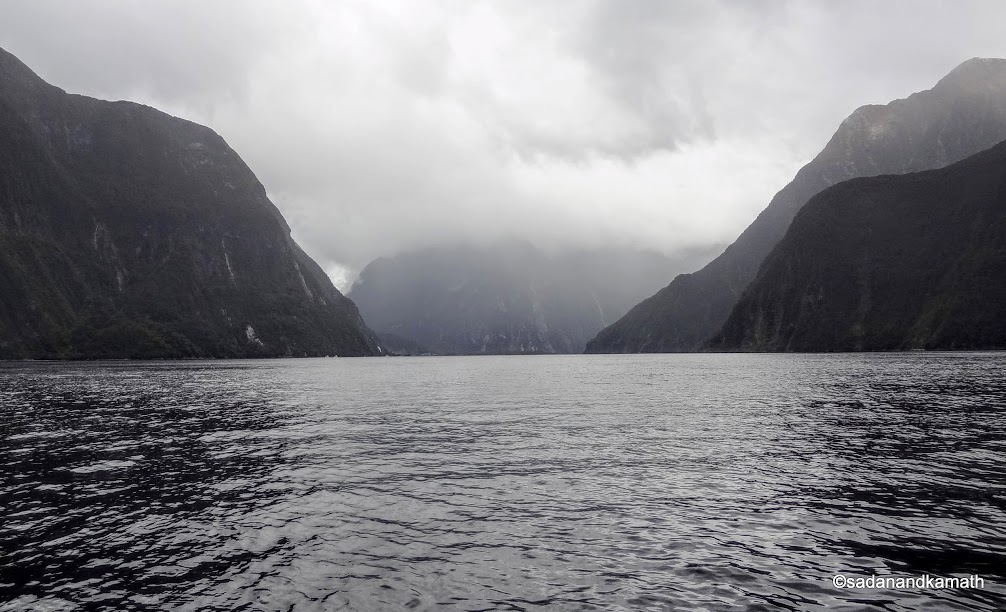
Milford Sound is a fiord ( narrow inlet of Tasman Sea running between high mountain cliffs) which runs 15 kms inland. Our cruise will go through a part of this fiord for the next 1 hour and 40 minutes passing through Bowen Falls, one of the two permanent waterfalls in Milford Sound. There are many small waterfalls on both sides of the fiord. Some of the mountains are as tall as 1400m from the sea level. Unfortunately, due to cloudy weather with hanging cloud, we could not see any snow-clad mountains. It is said that this region gets the highest annual rainfall (over 6000mm) spreading over almost a year. So there would be very rare occasions one to  cruise through the fiord under the blue sky.


The highlight of the cruise on its return journey was the viewing of Fur Seals resting on a rock and the drenching under Stiring falls when the boat  passed close to the  falls. For me, it was an awesome feeling to sail through the Milford Sound with a constant company of high mountains, some of them with rain forests as if they have risen from the water.
Bowen Falls, one of the two permanent waterfalls in Milford Sound. In the background is the pier from where we boarded the cruise boat.

One of the mountains covered in the mist.

A sample of non-vegetarian menu for lunch abroad cruise ship.

A panoramic view of a series of waterfalls from the mountains shot from the cruise boat.

A cruise boat is about to go near a waterfall for tourists to get drenched in Milford Sound.

Fur Seals resting on the rock in Milford Sound.

A tourist on the cruise boat rushing towards the cabin after getting drenched under the waterfalls.

The lucky ones on the upper desk who got drenched in waterfalls.

Mountain views from cruise boat in Milford Sound.

snow-clad mountain views from cruise boat.

This picture should explain what is the meaning of fiord. Sea water enters the inland in a narrow path with mountain cliffs on both the sides.

Exotic flowers in the garden of a restaurant in Te Anau town where we had coffee break.

We started our return journey to Queensland at around 3.00 p.m. After a coffee break at Te Anau town at around 5.00 p.m., we reached Queenstown at around 8.00 p.m. in the evening. Yes, it is evening in Queenstown at 8.00 p.m. as sun sets here at 8.30 p.m. at this time of the year and there is light till 9.00 p.m. After dinner, we returned to our hotel.

Queenstown - The Adventure Capital of New Zealand: Part-2 (under construction)


Monday, December 7, 2015

TranzAlpine Train - A Scenic Journey from Greymouth to Christchurch

I and my wife along with two of our relative couples were on a sight-seeing trip to New Zealand during November 17-27, 2015. We landed in Auckland and started our trip from Roturua-Waimoto Caves-Auckland. We flew to Queenstown and covered Wanaka, Milford Sound, Fox/Josef Glaciers  before entering our last leg of the trip to Christchurch.

After visiting Fox and Josef glaciers, we drove to Greymouth to board TranzAlpine train to Christchurch run by Kiwi Rails. I had read that this train, passing through Southern Alps, was among  the six best scenic train routes of the world. Having undertaken scenic train journeys from Interlaken to Jungfraujoch in Swiss Alps in 2005 and the Barrack Valley Express in North-East of my home country, India in 2011, I was keen to know as to how TranzAlpine train journey compares with these two scenic train journeys I had undertaken. The travelling from Greymouth to Christchurch meant that we were actually travelling from the shore of Tasman Sea on the west to the shore of South Pacific Ocean on the East.

We reached Greymouth station around 1.00 p.m. by which time the train from Christchurch had already arrived in the station. We checked in our baggage in the baggage car and carried hand baggages to the carriage. Our tickets were already reserved by the tour company. However, seats were allocated to us about 45 minutes before departure. The one-way fare from Greymouth to Christchurch is is flexible and normally ranges from NZ$120 (approx. Rs.5300/-) onwards for super-saver (non-refundable) category. The normal fare is NZ$189.  The train runs on the metre gauge track, hauled by two diesel locomotives. The distance between Greymouth and Christchurch is approximately 230 kms which is covered in 4 hours 30 minutes. 
The route of the TranzAlpine train in blue.

The train left Greymouth  10 minutes late from its  schedule time of 1.45 p.m. Since some seats were still vacant, we occupied window seat facing the direction to which the train was chugging. The glass window was very big to have good view of the sights. Almost all the passengers were tourists, mainly from India and other South-East Asian countries who seem to have taken this train as a part of their tourist circuit. Our carriage was towards the tail end and soon I found to my pleasure that the next carriage was a open air  coach without seats and windows. The tourists  could take photos without having to face the reflections from the glass. I spent most of my 4 hours of journey in the viewing coach for photo shoot. The train has a Cafe carriage with limited seating, serving hot beverages, light snacks, cold and alcoholic drinks etc. We relished coffee with cream.
  
Inside the carriage. The reclining chairs with sufficient  leg room make the journey very comfortable.


The journey can be divided into three distinct parts - (1) the rain forest area in around Greymouth until mountain climbs start before Arthur's Pass, (2) Over the Southern Alp mountains with the scenes of mountain peaks, valleys, Waimakariri river gorge, a couple of viaducts, many tunnels etc. This part of the journey is the most scenic. And (3) the plains of Canterbury with farmlands. The train stops at Arthur's Pass station for 5 minutes. Waimakariri river was our constant companion during the journey over the Southern Alps.

Wthout going into any more details, let my photos speak of the scenic journey more than me. 
 The passing of train made the herd of cows to run helter shelter just a few kms run from Greymouth.


The train on the first curve on the track. Still the mountains are not visible.


Yacht at the shore of Lake Brunner


Train halted at one of the stations before Arthur's Pass.


Waimakariri river at this point is almost in same level as the train track.


Train on the curve. This time the picture was taken from the open air carriage (partly seen on the left).


Train passes on the bridge over Waimakariri river.


Waimakariri river gets broader at this point.


Waimakariri river with mountain ranges in the background.


Waimakariri river.


A single lane road over Waimakariri river. This portion of the  road is after a rail crossing over the track of TranzAlpine train.


Waimakariri river with mountain background.

Probably a small town seen from the train.

Scene from the train. The inclination of the dry grass should give an indication as to which direction the train is moving.

One of the three viaducts on the route with this one ends at the start of the tunnel.

From the viaduct on the left, the train takes an almost 90 degrees turn over Waimakariri river.

Train enters one of 19 tunnels on this route. The tunnel near Arthur's Pass is the longest in New Zealand with a distance of nearly 7 kms.

Looks like Waimakariri river is encircled by hills.

Waimakariri river. But for the greenery around, I would have mistaken it to be Shyok river in Nubra Valley of Ladakh, India. 

With mountains giving way for hills and meadow, we are about to enter Canterbury plains.

The plains visible at the far end of the picture indicate that we are very close to Christchurch.

Train at Christchurch (Addington). Addington is located about 3 kms from the Christchurch City Centre.

Having completed the journey, the question will be asked as to whether the TranzAlpine train journey was really spectacular to spend about NZ$120. Before boarding the train, I had heard one of the tourists questioning the wisdom of travelling in TransAlpine train when the alternative mode of journey, that is by coach, may be cheaper probably blessed with more or less the same views of the Southern Alps. My view on train journey may be slightly biased as I am a train buff. For me, every train journey is an unique experience. Having said so, let me try to give my considered view on TranzAlpine train journey from a tourist point of view.

The TranzAlpine train journey may not be as spectacular as that of train journey in Swiss Alps from Interlaken to Jungfraujoch. But it is definitely scenic. In fact, those tourists with limited time at their disposal can get glimpses of mountains, river gorge, valleys in the comfort of a train. Since I have not travelled by coach in this route, I may not be able to compare the scenic beauties. But I have a feeling that the perspectives of Waimakariri river and its gorge may not look as beautiful on coach journey than on the train journey because the river flows very close to the train route. Then there is stretch around Waimakariri river  gorge which, in my view, can be seen only by train as there is no way a road can come to that much close. At least, I did not see the road in the vicinity of the gorge.

In any case, for most of the tourists, it is a trade off between cost of tickets and scenic beauties of the route. And this would decide their personal preference. I would  prefer scenic train journey rather than scenic coach journey as long as there is better comforts and  photo opportunities in the train  than in the coach as I experienced in the TranzAlpine train journey.