Showing posts with label Uttarkashi. Show all posts

Friday, April 14, 2023

Sangrali - An Off-Beat Village in the Vicinity of Uttarkashi Town

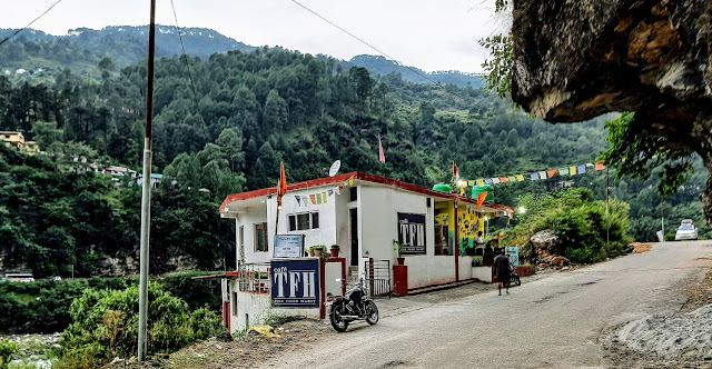
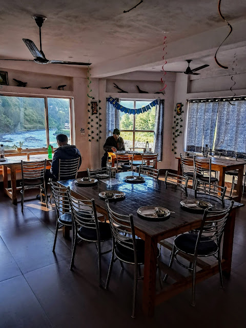
On my last visit to Uttarkashi in October 2022, the top portion of the dome of a temple on a mountain top was visible from Eagles Nest Homestay, 4 kms from Uttarkashi town. I was curious to know as to which was the temple and how to reach there - by road or by trek. Apart from my interest in the temple, I was sure that the view from the mountain top of the Bhagirathi valley would be spectacular. Since we did not have spare time to visit the mountain top, the matter was not keenly pursued. Even during my April 2023 visit to Uttarkashi, the idea of visiting the temple on a mountain top did not strike me. But I was destined to visit the place.

For our visit to Nelong Valley, my friend, Tilak Soni had arranged a SUV (Scorpio) which was to be driven by one Sandeep Semwal. He was introduced to me at the start of the journey as Sarpanch (Gram Pradhan) of Sangrali village close to Uttarkashi town. During the journey to Nelong Valley, he suggested me that we should visit his Sangrali village where Kandar Devta temple is located and revered by people of his village and other surrounding villages. He also generated interest in me by saying that from the temple, one gets a breathtaking view of snowclad mountains and the valley. He offered to take us on his village tour on the day we return to Uttarkashi after lunch. So, it became clear that the temple visible from the Eagles Nest was Kandar Devta temple.

Sandeep Semwal, the Sarpanch of Sangrali village with his vehicle on Nelong road. On the left is my son.

Driving route to Sangrali village.

After 3 nights of stay in Harsil, we returned to Uttarkashi in the forenoon. On reaching Eagles Nest, we came to know that Sandeep Semwal who was to take us to his village Sangrali that afternoon had gone out of the town on some work. So, we resigned to our fate that on this occasion also, we would not be able to make it to the temple as the next day after breakfast, we would leave Uttarkashi for Dehradun.

Next day, after the breakfast, we were ready for the departure from Eagles Nest for Dehradun. The vehicle came in time. At that time, my son suggested that we should take a detour to Sangrali village and then drive to Dehradun which would require at least an additional hour. The driver agreed provided we pay for the extra kms of drive. We agreed. At last, the plan to visit Sangrali village with Kandar Devta temple and the mountain top view from there is going to fructify.

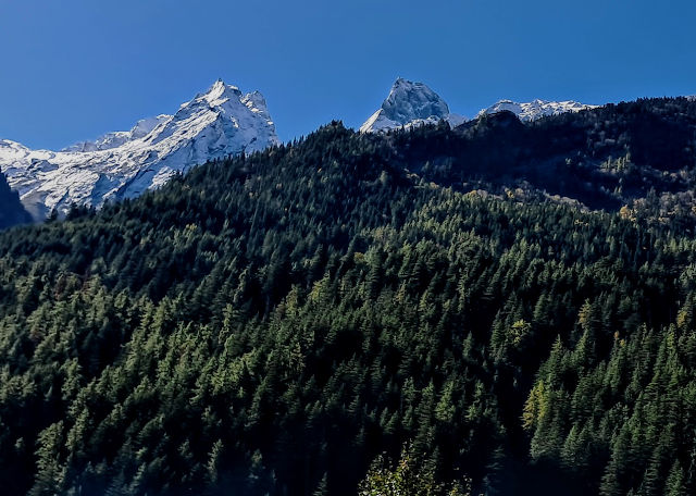
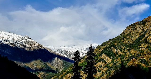
From Eagles Nest, after crossing Thekla bridge and moving towards Uttarkashi town, the immediate right 'U' turn on the ascending road goes to Sangrali village. The 11-km zig-zag drive was on the excellent road surface. We reached the gate of Sangrali village in less than 30 minutes. I was pleasantly surprised that despite the hilly terrain, the Gram Panchayat had created a parking space on a plain surface sufficient to cater to at least a dozen vehicles. We got down from the vehicle and the first thing we saw was the snowcapped Bandharpunchh range in a clear blue sky.
Bandharpunchh West and Bandharpunchh East both on the right from Sangrali.

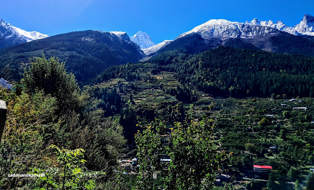
Kandar Devta temple on the left foreground with snow-capped mountain in the background. The middle gap is Bhagirathi valley. A local person told me that the peak on the left is Draupadi Ka Danda.

A partial view of the Sangrali village from the cemented pedestrian path.

The topography of Sangrali village is such that Kandar Devta temple is located on the top of the mountain. The houses are located around the temple in layers in descending orders according the to the height of the place. All the houses are well connected with the cemented pedestrian path. Most houses have slat roofs though there are few bungalows. At lower levels, there are terraced fields. I had talked to a couple of people in the temple premises who told me that Sangrali village is located on Varnavrat mountain. Around 110 families stay in the village. The literacy rate is high as apart from primary school in the village, the students have easy access to higher secondary schools in Uttarkashi town.

For the people of Sangrali and the surrounding villages, Kandar Devta is their protector. He is the manifestation of Lord Shiva. People believe that everything in the life of villagers - education, marriage, farming, inter-personal disputes etc are decided by Kandar Devta.
Kandar Devta temple.


Idols inside Kandar Devta temple.

View from Kandar Devta temple.  Gangori village off Bhagirathi River with Bandarpunchh West and Bandarpunchh East in the background.

Another snow-clad mountain view from Kandar Devta temple. The peak on the left is Draupadi Ka Danda according to a person from the village.

Panchayat Bhawan, Sangrali village.


Coming out of the Kandar Devta temple gate.


View of Bandharpunchh range from Parking lot of Sangrali village.

Since we had only limited time at our disposal, we just visited the peripheral of the village around the temple only. There are lot more to see in the village from the other side towards Uttarkashi which we could not do. The priest also told us that a visit to Vimleshwar temple, located off the road about 2-3 kms from Sangrali village was also a good point for the view. This involves about 2 kms of climb to reach the temple. In short, one needs to have almost 5-6 hours to complete the visit on Varnavrat mountain top. Within the limited time at our disposal, we could get a feel of the village. Probably, in our next visit to Uttarkashi, we will keep one full day for Varnavrat Mountain top.

Sunday, October 30, 2022

Eagle's Nest - A Home Away from Home

K. Srinivasan and I stayed with our friend, Tilak Soni for 3 nights in his house which he has named as 'Eagle's Nest' during our recent one-week sojourn in Uttarkashi-Harsil-Gangotri circuit involving three day-treks and three village walks. The house is located in Mando village, 4 kms from Uttarkashi town on Kedarnath road.  Sitting in an open porch outside our room and watching the gentle flow of emerald-colour water of Bhagirathi River amidst the surrounding mountains covered with dense forest gave us an opulence feel. Tilak told us that he had often seen deers roaming on the top of the hills and occasionally leopards also. The guests in 'Eagle's Nest' do not need a swimming pool as they can have more or less the same feel in Bhagirathi River with its somewhat calm flow and the shallow water by walking a few steps. 

Eagle's Nest on the right, Bhagirathi River on the left.


View of Bhagirathi River from the open porch of Eagle's Nest. On the left is Kedarnath Road.

This was our room during our stay in 'Eagle's Nest'.


The open porch outside our room to view Bhagirathi River while sipping coffee.

I have known Tilak Soni for the last 14 years - first through an India related travel portal where we both were members. Sometime in June 2011, K. Srinivasan (KS), my trekking partner and I, on a short break in Delhi on our way to Joshimath for Changbang Base Camp trek, had personally met Tilak for the first time. In May 2015, on our completion of Dodital-Darwa Top-Dayara Bugyal round trek, we had returned to Uttarkashi. When Tilak came to know about our presence in Uttarkashi, he personally came to pick up us from our hotel room and took us to the then rental house about 3 kms further toward Gangotri side. At that time, he had told us that in our next visit to Uttarkashi, we should stay in 'Eagle's Nest' as his guests. That occasion came recently after a gap of 7 years. 

Me and K. Srinivasan at 'Eagle's Nest' on May 31, 2015, after our return from Dodital-Darwa Top-Dayara Bugyal round trek.

When we planned for our ramblings in Uttarkashi district scheduled in October 2022, I apprised Tilak through e-mail with our schedule of visit to Uttarkashi and our plan to stay with him. He immediately confirmed by replying that he has noted the dates in his diary.

With three days' stay in his house, the opportunity for inter-actions with Tilak was much more than our casual meets earlier. I came to know many things about him - especially about his transformation from a savvy urban man from Delhi to a rugged hillman. Tilak left his lucrative corporate job in Delhi and decided to settle down in Uttarkashi in 2010. His was an interesting story and I felt that I should write about him, about his 'Eagle's Nest' and his venture, 'Cafe TFH'. 
 
Cafe TFH - The Food Habit on Kedarnath Road. The gate near the Cafe leads to 'Eagle's Nest'. The bus on the left is on Gangotri Road.

Tilak Soni in the kitchen preparing the herbal tea for us in the morning. The dining room can be seen through service area from the kitchen. 

View from Cafe TFH of Bhagirathi River.

Tilak's family belongs to Nawalgarh in Shekhawati region of Rajasthan. However, they have been staying in Delhi for over three decades. When he got a corporate job in Delhi, Tilak used to ride on his motorcycle (bike) to reach office. Over a period of time, biking became his passion. He started weekend travelling on his bike along with his close friends. In one of such group travels, he rode his bike from Delhi to Gangotri sometime in 2002. He liked the hill atmosphere so much that he made the bike ride on Gangotri road an annual feature. During such bike-rides, he had inter-acted with some sadhus and mystique men Slowly, he was drawn to spirituality. He enjoyed the tranquility in the mountains. He felt that he was more inclined towards spending life on the mountain settings than the urban concrete jungles. So, after giving much thought over it, in 2010, he decided to resign from his corporate job, leave Delhi for good and shift to Uttarkashi to be in the company of Bhagirathi River and Vishwanath temple.

In the initial years, Tilak stayed in a rented house, about 3 kms from Uttarkashi towards Gangotri side. Having left the job, he had to find some vocation in Uttarkashi which would not only keep him busy but also earn some income for the sustenance. He decided to take up the vocation for which his expertise was proven - organising mountain bike ridings (both motorcycles and bicycles), trekking expeditions, hiking to unexplored places and village walks. During this period, Tilak also completed the Basic Mountaineering Course Certification Course from Nehru Institute of Mountaineering, Uttarkashi in 'A' Grade.   With this, he was now ready to start his vocation for which he set up 'Where Eagles Dares' to undertake outdoor adventure activities.  He said that he was pioneer in organising the first snow-biking from Uttarkashi to Gangotri. Since then, it has become an annual event. He had also participated in season's opening of the treks in the Gangotri region like Kedartal, Tapovan etc. Among his many trekking expeditions, Tilak successfully completed Kalindi Khal Pass (5940m) which joins Gangotri region with Badrinath.

When Uttarakhand Government opened the 24-km stretch of Bhaironghati-Nelong road for Indian civilians for driving trip, Tilak along with 5 other cars were the first civilians to travel. Another feather in Tilak's cap was his concerted efforts with the concerned departments of Uttarakhand Government (such as Forest, Tourism, Public Works) to repair the damaged wooden stairs of Gartang Gali and open to Indian tourists to trek. His efforts bore fruits and in August 2021, the 2-km Gartang Gali trek was open for Indians with some restrictions. He is now pursuing with the same departments to extend the trekking coverage of Gartang Gali from the present 2 kms to 7 kms (up to a point where the trekking path meets the Bhaironghati-Nelong road). 

The idea of starting Cafe TFH in 2018 germinated from the need to serve his guests the varieties of food - Indian, Chinese, Continental etc. The menu card of the Cafe gives a good indication of his intent.  Leaving alone in Uttarkashi away from his parents made Tilak to learn cooking. Today, he has become a good chef not only to take care of his own food requirements but also of his guests and the visitors to his Cafe TFH. He can also serve food which are not listed in the menu card, for example, Sizzlers.  During our three days of stay with him, he personally cooked breakfast for us as his cook would come only around 9.00 am at that time. We had an authentic feast of South Indian dishes like Masala Dosa, Rava Dosa, Idli with filter coffee. KS had never expected that in Uttarkashi, he would get Curd-Rice with fried red chilies and curry leaves, a specialty South Indian food. The sambhar and chutney personally prepared by Tilak were testimonial to his expertise on making South Indian food. I do not think that such authentic South Indian preparations would be available elsewhere in Uttarkashi.

The dining room. One can see Bhagirathi River through windows.


The menu card.


The lounge outside the dining room of the Cafe.

As I mentioned earlier, Tilak had his 'Eagle's Nest' on a rented premises. In 2018, after opening Cafe TFH, the land behind the Cafe was bought by him. After registration, he constructed his present 'Eagle's Nest' with 3 bedrooms, one of which is for his personal use. With extra beds, six guests can be accommodated in remaining two bedrooms. However, in case of need, Tilak gives his bedroom also for the use of his guests by shifting himself in an adjoining anteroom which has a separate exit. He told me that he has no plan to construct additional rooms though there are space enough to construct two more rooms. He has a plan to construct a ramp by the side of his Cafe on the right so that guests need not use steep stairs to descend from the road to reach the rooms.

Tilak with myself (left) and K Srinivasan (right) outside his Cafe just before our departure to Dehradun.

Tilak gives first preference to his adventurous friends numbering about 9000 to use his house for overnight stay on their ways to/return from adventurous activities in the Gangotri region. His rooms are also available for those who need to stay somewhat longer time in Uttarkashi in pursuing their research works in the Gangotri region. Others can book the rooms provided they are referred to by his friends and rooms are available.  

There is no room tariff. Instead, Tilak has left to his guest-friends to donate the money as per their ability. Tilak says that to the best of his knowledge, all the guests donated the money as per their capacity. Most of his guests donated generously. The donations are used for day-to-day maintenance of the property and for adding some more facilities for the benefit of the guests. Tilak has also made available to the guests the free Wi-Fi facilities, both in rooms as well as in the Cafe. He has good collection of books in the library which the guests can use for reference.  

Tilak calls 'Eagle's Nest' as a homestay. But I would like to call it a home away from home. I have already decided that in my next visit to Uttarkashi which may be as early as next year, 'Eagle's Nest' would be my abode. At that time, it would be more of a leisure stay to have the full benefit of the culinary expertise of Tilak.  


Saturday, October 22, 2022

Rambling in Uttarkashi District: Part-5 - Visit to Mukhba Village, the Winter Abode of Maa Ganga

October 13, 2022

We woke up early and had our morning tea. The weather was superfine with complete blue sky. The snow-clad mountains looked more splendid than the previous day with the background of dark blue sky. This prompted us to take a walk and shoot the snow-clad mountains. 

Morning view from Harsil market.


Morning view of Mt. Harsil Horns from the garden of our homestay.

We had scheduled a walk to Mukhba village from Harsil (3 kms) yesterday afternoon. However, the rains spoiled our planned walk and we decided to skip the visit. Today, after the breakfast, we had scheduled to return to Uttarkashi on our back home journey via Dehradun. It was during the breakfast that we thought of requesting the driver of our hired taxi to drive first to Mukhba village for a quick visit and then proceed to Uttarkashi. The driver agreed. 

Our homestay was located on Harsil-Mukhba road and it was a 3-km journey parallel to Gangotri road with Bhagirathi River flowing on the right side. Within 10 minutes, we reached Mukhba village at around 10 a.m. The staircase leading to Maa Ganga temple complex was on the left side of the road itself.

Mukhba road (left), an unnamed peak in the background and Bhagirathi River in the foreground.


Way to Maa Ganga temple, on the Mukhba road, Mukhba. 
Photo by K Srinivasan.

The moment we reached Maa Ganga temple complex after climbing the stairs-cum ramp, we realised that this was not the place for a quick visit but for an easy pace visit. From the temple premises, we got a clear view of snow-clad mountains with some prominent peaks like Mt. Srikantha (6135m) and some unknown peaks. 

Mt. Srikantha (6135m) in the middle shot from Mukhba village. In the foreground is Uttarkashi-Gangotri Road going towards left to Gangotri via Dharali village.

Zoomed shot of Mt. Srikantha


An unknown peak seen from Maa Ganga temple complex in Mukhba village.

Mukhba village is predominantly the home of Semwal brahmin family, a priestly class. The priests of the Gangotri temple hail from Semwal brahmin settled in Mukhba village. For the very reason, they are also the priests of Maa Ganga temple in Mukhba. This temple is the winter seat for the idol of Maa Ganga in Gangotri which is brought here after the closer of Gangotri temple in around Diwali. The idol is brought to Mukhba in procession from Gangotri. On the way, the idol is kept overnight in Markendeya temple, on the banks of Bhagirathi River. On the next day, the idol is brought to Mukhba Maa Ganga temple which will be Her winter abode until Akshya Tirthya day (sometime in early May) when the idol would be taken to Gangotri in procession.

The old wooden Maa Ganga temple with newly constructed annex in Mukhba village.


The new Maa Ganga temple in Mukhba village is almost a replica of Gangotri temple.


The new and old Maa Ganga temple with the background of snow peaks. In this picture I am talking to a person from Semwal family about the temple and village. Photo by K. Srinivasan.


An artistically carved wooden house annexed to old Maa Ganga temple.


Me and KS in front of new Maa Ganga temple.

Most of the houses in Mukhba village is made of Deodhar wood with some artistic carvings. But some of them have become very old and are in depleted conditions. A few houses seem to have been abandoned. These houses actually represent the Garhwali heritage. They look elegant even in depleted conditions.
Mukhba village with wooden houses. The blue sky, the green pine trees on the upper part and the appearance of fall colours on some trees in the middle, lend a colourful decor to the village.


A abandoned wooden building. Probably, it is now being used as a store house.


A wooden house in upper Mukhba village.


View of Dharali village with Mt. Srikantha in the background and Bhagirathi River in foreground.


View of snow-clad mountains with Bhagirathi River from Jaspur village on our way back to Uttarkashi.

We spend about 30 minutes in around Mukhba temple and really felt that if we had the time, we could have strolled in the village. Probably, we would have got some vintage points to shoot the sceneries beside some more pictures in the village. For instance, if we have walked to the upper part of the village, we would have got the view of Maa Ganga temple with beautiful landscape and with the background of full snow-clad mountains. Also, we miss to visit Markendeya temple, 1-km walk from the village with its picturesque location on the banks of Bhagirathi River. The village is also the starting point for day treks like 2-km Thui Top trek, 5-km Nangani Taal trek and 8-km Sattal trek. The village is also the starting point for 12-km 2-day Kyarkoti Bugyal trek.

We commenced our return road journey to Uttarkashi from Mukhba at around 10:30 a.m. and reached Uttarkashi for lunch at Eagle's Nest. We stayed overnight here. Post-lunch, Uttarkashi experienced heavy rains which lasted till late evening.  In the next day, after breakfast, we proceeded to Dehradun in excellent weather conditions.


Friday, October 21, 2022

Ramblings in Uttarkashi District: Part-4 - In Harsil: Trek to Lama Top

October 12, 2022 

We woke up to a knock on the door of our room in Sundar Homestay exactly at 05:30 a.m. It was Shailender, the multi-tasking person of the Homestay, with cups of tea in steel glasses. I had never expected that in mountains, we would get the bed tea so early. Even in Uttarkashi, a big town, we would have to wait for one more hour to get bed tea. I went out to the balcony with my bed tea in hand to observe the weather condition. In the twilight, the weather looked excellent for Lama Top trek which we will be attempting after the breakfast. The sun had risen by now. I went out for a stroll in the Harsil market. With the afternoon rains in the previous day, the upper reaches of the mountains surrounding Harsil seem to have received fresh snow. 

Morning view from Harsil market with fresh snow on the mountains in the background.


Morning view of Mt. Harsil Horns from the garden of Sundar Homestay.


Red apples on the tree with a background of the blue sky in the garden of Sundar Homestay.


Trek to Lama Top (3+3Kms)

I became aware of Lama Top trek only few months back when I was researching on our proposed trip to Harsil. After watching a couple of videos on Lama Top trek, I felt that I must do this trek though it required a 3 kms of almost continuous climb, gaining around 400m in altitude to reach the top.

After finishing the breakfast around 9:00 a.m., we packed our respective backpacks with umbrella, some eatables and 1 litre of water bottle. We walked towards the main gate of Army cantonment to take an exit to the right and crossed the pedestrian iron bridge. The trek to Lama Top starts at the right turn after the bridge. Immediately, we were on a gradual climb which continued until we reached a viewpoint after about 20 minutes.

View of Lama Top from the street of Harsil.

Starting point of Lama Top trek. The right turn at the end of the bridge is the route to Lama top. Photo by K. Srinivasan.

The initial part of the trek goes along Jalandhri River on the right side.


On the Lama trek path.

Some rest in the backdrop of Mt. Harsil Horns.


Harsil Valley with Harsil village seen from the trek route.

The main trek path is well laid thanks to the Jadh Bhotiyas of Bagori village who had done the initial laying down of the trek path to enable them to worship on Lama Top. There are some subsidiary paths and diversions on the initial part of the trek. Eventually, they meet the main trek path after few metres, So, there is not much worry about losing the path. The soft soil on most part of the path covered with dead leaves and dry grass and with almost 45-degree gradient of climb, and similarly ascend on return trek, the chances of slipping on the trek is high. This is especially so if trek path is drenched in rains. 

It had rained in the previous afternoon in Harsil which continued till late evening. Our homestay guys had advised us to avoid trek to Lama Top if the rains continued on the next day. So, I would strongly advise to those who wish to visit Lama top to carry a trekking pole (or wooden stick) and wear shoes with good grip. Also carry some eatables and sufficient water as there is nothing available on the 3-km trek route.


View of Bhagirathi River from the trek route.

Despite steep climbs we faced, the good thing about this trek path is that we came across 3 viewpoints where we could enjoy the sceneries and at the same time get some rest to bring back our breathing to normal. In the entire 3-km of trek, we were the only two persons on the trek. It was only on our return trek we came across a Bengali lady who came with a guide.

From this point, it is a steep climb up to Lama Top.


Note the steepness of the climb from right. Still more to climb.


Looking at the prayer flags and the flat top, I first thought we have reached the Lama Top.


We also took a couple of pictures 


But there was still about 50m of steep climb off the cliff to reach Lama Top.

After a steep ascend of about 20m on narrow stone steps off the rock cliff followed by equally steep climb, again on stone-made steps off the cliff, we reached the Lama Top. It took about 2 hours to cover the 3-km of distance. The first thing we observe on reaching the top was fluttering of hundreds of prayer flags because of the strong breeze. Yet there was no view of Harsil Valley. A climb of one step on a flat rock and standing on it gave virtually 270-degree view of Harsil Valley with Mt. Harsil Horns in the far-end and Harsil and Bagori villages with Bhagirathi River at the base of the Valley. I was looking at my shoes to ensure that I was standing firmly on flat rock to face the strong breeze, and that very moment I also saw the Harsil Valley down below

It is interesting to note that in the morning, when I was in Harsil Street, I looked up to see the Lama Top Mountain which stood vertically. Now, I am on Lama Top, and looking down to see Harsil village. What a contrast. Another contrasting feature of the place is that though it is just 3 kms from the hustle-bustle of pilgrims enroute Gangotri and tourists in Harsil, Lama Top is a place for solitude lending a spiritual atmosphere. The pleasure of spending some time in deafening silence except the occasional sound of fluttering prayer flags on Lama Top is more than compensated by the hardship faced in steep climbing for reaching this place.

Lama Top is a worshipping place for the Jadh Bhotiyas living in Bagori village and around. It is a place for them to get their wishes fulfilled. First, they visit praying for their wishes be fulfilled. After their wishes are fulfilled, they visit once again for thanksgiving. At each visit, they host prayer flags as has been the ritual among the Bhotiya Buddhists. 


View of Harsil Valley from Lama Top. Harsil village with Bhagirathi River in the foreground and Mt. Harsil Horns in the background.


Coins imbedded in a dead tree trunk at Lama Top. It is the belief that wishes will be granted for each of the coins embedded.


Influenced by a spiritual feel, I am sitting in a meditation mode on Lama Top.


Returned to Bagori village path from Lama Top.


This was the place where Pahadi Wilson's wooden house was located. After a fire destroyed his house, a new house has been constructed by Forest Department as Rest House for visiting Government officials.

After spending about 30 minutes on Lama Top, we commenced our return trek. The weather had turned partly cloudy and the chances of rain showers after some time seems imminent. But the steep descend was also equally difficult in balancing oneself. Still, we could complete our return trek in about 45 minutes without taking any break and viewing sceneries. After reaching, we realised that we had unknowingly taken a different trek route which brought us down to a car parking place on the way to Bagori. So, it can be construed that those living in Bagori would use this trek path for Lama Top while those in Harsil would use the path on which we commenced our trek in the morning.

We returned to our Homestay by 01:00 p.m. After lunch, we had planned to walk 3 kms to Mukhba village to visit Maa Ganga temple and take a walking tour in the village. However, the continuous rains in the afternoon stretching till dusk forced us to abandon the plan.