For a travel enthusiast like me, there is an immense pleasure when a trip is suddenly decided. Our Kerala trip ( Munnar, Thekkady and Alapphuza) was one of such trips. My wife told me in mid-Ocotber that she would have one week's free time in the first week of November. The immediate thought was to make a trip to Choukari - Munsiary areas of Kumaon Himalaya which I was planning to visit some time in 2009. " Enough of your Himalayan trips " my wife responded to my silence as if she had read my mind. "This time we are heading for south" she said with an air of finality. As we had not visited Kerala hills, we settled for Munnar and Thekkady. A quick browsing through internet for hotel bookings revealed that rooms were not available in hotels/resorts in which we would have liked to stay based on reviews. Since the time was short and it was the peak Diwali season, I approached Kerala Tourism's Office at Cuffe Parade to get necessary assistance in booking hotels and car. Finally, I settled for Munnar (3 nights), Thekkady (2 nights) and Alaphuzza (2 nights).
Day-1 : Mumbai-Kochi-Munnar
We reached Kochi by an early morning flight. Rajeev, the driver, was already at the concourse of the Kochi Airport to receive us. Our car journey to Munnar (120 kms) commenced at 10.00 a.m. in a pleasant morning weather with a clear blue sky. We passed through Kalady and Perumbavur before joining NH49 at Kothamangalam. From here onwards, ghat section of the road started. It was, however, a pleasant drive on a good road with hardly any sharp curves or hairpin bends. The traffic on the road was light. After about one hour drive from Kothamangalam, we encoutered the first waterfalls - the Cheeyappara waterfalls close to the road. This seemed to be picnic spot for locals as we saw a moderate crowd enjoying the waterfalls cascading down in seven steps. This was the biggest of the three waterfalls which we saw on Kochi-Munnar Road.

Cheeyappara waterfall on Kochi-Munnar road
The region had experienced heavy rains about a week before our trip, resulting in heavy flow of waterfalls. The forest cover as well as the surroudings of the waterfalls looked fresh green.

Dense forest on Kochi-Munnar Road
We crossed two more waterfalls before reaching Pallivasal where we had a first wholesome view of the rolling tea plantations. We reached Munnar around 2.00 p.m. and checked in Westwood Riverside Resort ( http://westwoodmunnar.com/ ) located about 2 kms before Munnar town. From the balcony of the resort, we could see a rivulette flowing through grassy land and trees dotted with blooming red flowers.
After a late lunch at the Resort's restaurant, we went for a stroll to Munnar Town in a pleasant weather condition. Surprisingly, the town was not as crowded as one would expect during the post-Diwali holidays. My guess was that most of the crowd comprised of week-end tourists from nearby places and the packaged tourists from Maharashtra and Gujarat.
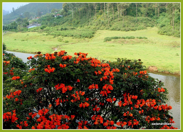
One of many red flowers trees seen from the resort
Day-2 : Mattupetty Lake-Echo Point-Kundalay Lake-Top Station
I got up early in the morning and opened the balcony door anticipating the cloud-mist play for which Munnar is famous. What I saw was a clear blue sky without any trace of cloud or mist. I could see a thin mist rising just above the rivulette, moving with the gentle flow of water which meant that water in the rivulette was warmer than the outside temperature. This scene continued for the next two days of our stay thus completely missing the misty days in Munnar.

Munnar Town seen from Floriculture Centre
After a hearty breakfast, we commenced our journey for Mattupetty lake. Just 2 kms outside Munnar town was the Floriculture Centre, locally known as Flower Museum. We spend about an hour or so admiring the vast number of flowers and cactus. The location itself is superb as it is surrounded by a vast expanses of tea plantations on the valley side and the eucalyptus tree forest on the hill sides.
 |
A side road to tea plantations seen from Horticulture Centre, Munnar.  One of many flowers on show at Horticulture Centre, Munnar. |

Eucalyptus tree lines at the edge of tea plantation
Our next destination was Mattupetty lake which was about 10 kms further from Flower Museum on road to Top Station. It was pleasant to watch arrays of tea gardens and green hills dotted with tall eucalyptus trees during the road journey. Mattupetty dam and lake areas seems to be one of the favourite week-end destinations. About 2 kms walk over the dam led us to the boating point from where one can have a choice of rowing or speed boats. We took a 30 minutes speed boat ride in the lake as we ate on the way the juicy fresh pineapple slices bought from one of the road side vendors.

Mattupetty lake

Boating in Mattupetty lake
The sceneries enroute to Kundalay lake was once again amazing. Apart from now familiar sights of tea gardens and tall eucalyptus trees, we could see many small grassy meadows by the sides of the road as wells as on the hills. On the way, we took a brief stop at Echo Point where one can hear the echo of our voices. If one has the time, a long walk on the side path of the lake may be a worthwhile proposition.

One of the many meadows on way to Kundalay lake
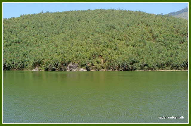
Echo point
From Echo Point to Kudalay lake, the road passes through predominently eucalyptus tree lines. We saw many of these trees being cut under the supervision of the forest officials and dumped on the road sides. Looked like old trees have to make rooms for the new ones.
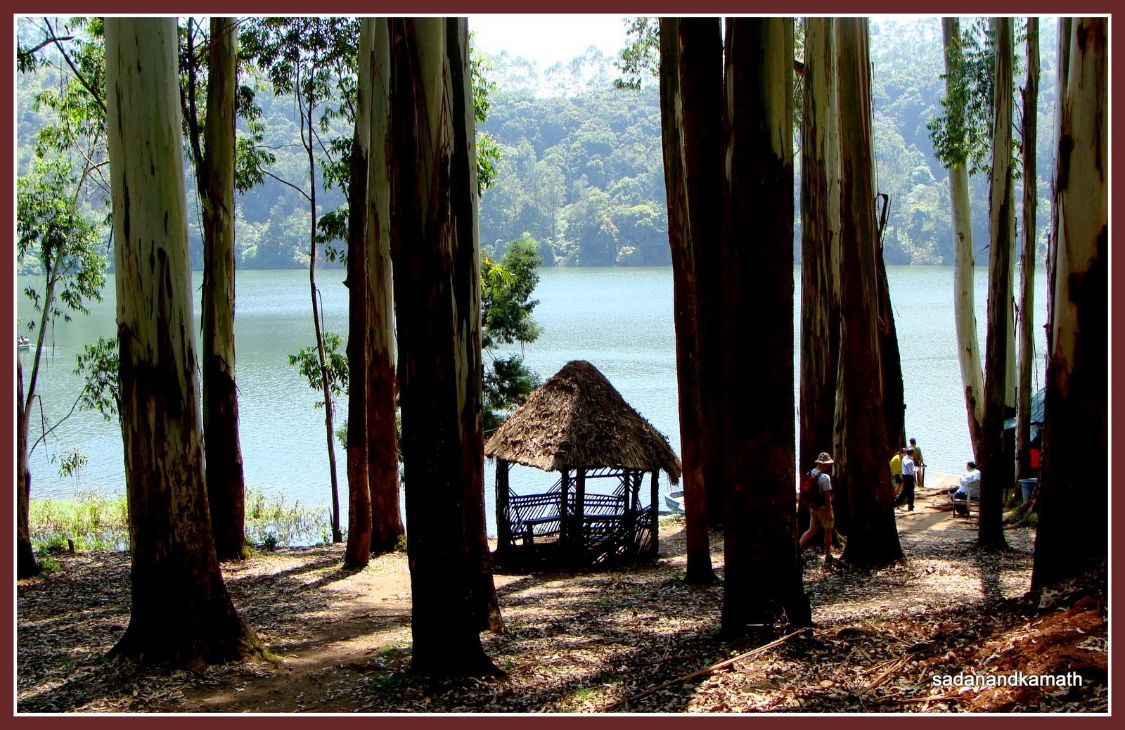 |
| Kundalay Lake through silver oak tress |
 |
Boating in Kundalay Lake |
The shape, the surroundings and the dense tree shades at the shores make the Kundalay lake more picturesque than the Mattupetty lake. Even the boating facilities - pedalled boats and the shikara type boats lend a romantic aura to the whole place. For a moment, I felt as if I was in the lap of Himalaya ! This lake made my day.
Top Station is about 14 kms drive from Kundalay lake. Again we had the beautiful views of the rolling tea plantations spread around the hills and valleys. Just about 2 kms before the Forest check post, the road conditions suddenly become bad. Our driver told us that we were now in Tamilnadu and the same road would go to Kodaikanal. From Munnar, this route is the shortest to reach Kodaikanal but according to my driver, it takes more time than the longer route via Teni as Top Station-Kodai road is in poor conditions.
 |
| Way to Top Station |
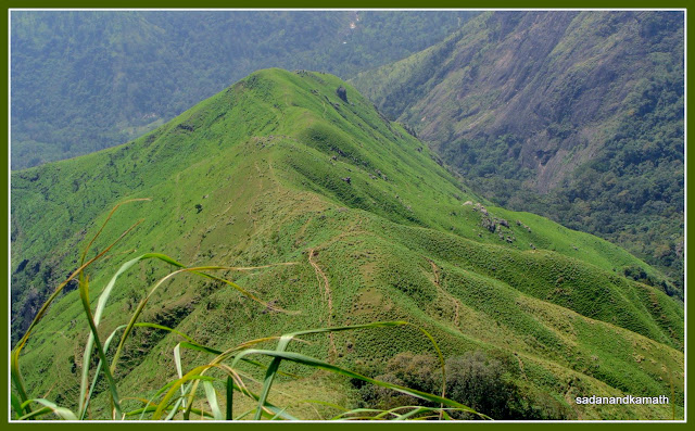
A grassy hill as seen from Top Station View Point
From the forest check post, it was about 1 km walk to Top Station View Point - a steep climb down followed by equally steep climb up to the View Point. The sky was clear and the weather was a bit warm. One need to carry water bottles as nothing is available after the forest check post point. There are trekking trails leading to the surrounding forests for which one needs to take permit from the forest office.
From the View Point, dense shola forests of Tamilnadu and Kerala on both sides of a grassy hill (which, in my view, looked like a miniature of Ali Bugyal in Uttarakhand Himalaya) were clearly visible. After spending about 30 minutes at View Point, we returned to our Indica car which was parked at the dead end of road and the beginning of the local shops. Most of the shops were selling some fruits which looked like oranges from a short distance. The locals call it Passion fruit. My wife was curious to know about this fruit. The outer cover of the fruit was firm. One of the shopkeepers cut the fruit from its top edge, removed the jelly like pulp from inside of the fruit and gave us for tasting. It had a nice and sweet taste. The pulp also contained very small black seeds. The shopkeeper assured us that this fruit would remain good for about 7 days. We bought 1 dozen of Passion fruits, two of which carried back to Mumbai. The shopkeeper was right. The fruits were good enough to eat in Mumbai.
 |
| Dense shola forest with some tea plantations in the background seen from Top Station |
We returned to Munnar Town by 3.00 p.m. We had sumptuous and tasty South Indian vegetarian meals served on banana plantain leaves at Saravana Bhavan. At Rs.27/- per meal, it was cheap too.
Our first stop was Tea Museum, hardly 2 kms from the Munnar Town. The Museum opens at 9.30 a.m. but we reached the place by 9.00. There was no other visitors except one foregn tourist and us. However, we were issued entry tickets and allowed us the entry earlier than the scheduled time. We spent some time in the Photo Gallery displyaing pictures showing the various types of tea making processes. Thereafter, we were shown a documentary film of about 30 minutes duration on the history of the Munnar tea plantation. Suffice to say that about 85% of the tea plantations in Munnar which were owned by Tata have been converted in to a society in which the workers have 69% of shares, Tata has 18% and rest are held by ex-employees. As more visitors joined us, we were taken to their factory floors where one of the officials of the Museum explained to us the process of turning the tea leaves to the six basic varieties of tea. We spent about one hour in the Museum and had the complimentary tea.

Tea plantations in front of Tea Museum
A 13 kms drive from Tea Museum took us to the gate of Eravikulam National Park (ENP). There was already a long queue for park tickets. We were in two mind whether to skip ENP and proceed Marayoor or stand in the queue. The park has six mini buses ( 22 seats each) to take the visitors to ENP. Our guess was that not more than about half-an-hour or so to get our turn in the bus. Hence we decided to see ENP first and than proceed to Marayoor. But we were wrong. It took us about an hour to reach the ticket counter and further 15 minutes to get into the bus.


Nilgiri Tahrs at Eravikulam National Park
The bus journey t ook about 20 minutes on a 5 kms winding single lane road to drop the tourists near the park centre with small museum, a sale outlet for spices and local chocklates, a tea stall and rest rooms. From here, we had a panoramic view of the vast expanses of tea plantations inside EPN. We walked for about 2 kms before we could spot a group of Nilgiri Tahrs. Some of them came very close to the road and we could caress them which they seem to like. A further 500 m or so took us to a point from where one would require permission from the Forest Department to trek deep inside the park. From here, one could see Anaimudi peak (2695m), the highest peak in South India from the close range.
ook about 20 minutes on a 5 kms winding single lane road to drop the tourists near the park centre with small museum, a sale outlet for spices and local chocklates, a tea stall and rest rooms. From here, we had a panoramic view of the vast expanses of tea plantations inside EPN. We walked for about 2 kms before we could spot a group of Nilgiri Tahrs. Some of them came very close to the road and we could caress them which they seem to like. A further 500 m or so took us to a point from where one would require permission from the Forest Department to trek deep inside the park. From here, one could see Anaimudi peak (2695m), the highest peak in South India from the close range. 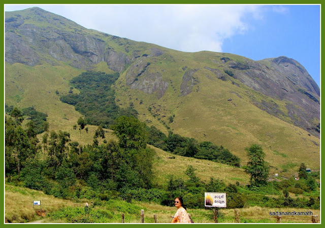
Anaimudi peak (2695m) seen from Eravikulam National Park

A nice resting place in the backdrop of Anaimudi peak
It was 2.30 in the afternoon when the bus dropped us to the ENP gate. We were planning to have a quick brunch before proceeding to Maryaoor when our driver told us that the road to Marayoor was in bad shape and we may not have enough time to come back Munnar before dusk. I checked with one of the locals and he was of the view that the time was too tight to visit Marayoor, do the sight-seeings and return to Munnar. He advised us take return journey from Marayoor well before dusk as there was possiblities of elephant herds crossing the road. So we dropped the idea of visiting Marayoor. Afterall, we should keep something for the next visit !!

A panoramic view of tea plantations from Eravikulam National Park
On a hindsight, it would have been better for us to visit Marayoor first in the early morning and do the Eravikulam NP bus ride in the afternoon as we observed that there were very few tourists in the queue for the bus ride to ENP. If time permitted, one could visit the Tea Museum on way back to Munnar. Even if one missed the visit to the Tea Museum, it was not a great loss as compared with not visiting EPN and Marayoor.
We returned to Munnar Town by 3.00 in the afternoon and had a quick south Indian lunch at Hotel Srinivas which was as tasty as of Sravana. After taking a walk around the shopping centres and buying some spices, we returned to our hotel room and spent some evening time in the balcony. The rivulet with its slow flowing water through the meadow, cows resting on the meadow - some of them grazing - and lines of eculyptus trees on the hills in the background gave me a feeling as if I was in a Himalayan village. But the cloud-mist play still eluded us.
It was a sad feeling for us that we would be leaving Munnar for Vandanmedu the next day. How quickly the last three days had passed though we had only the glimpses of Munnar and its surroundings and I was beginning to fall for Munnar. In my view, one should spend at least 7 days in Munnar to explore it in a better way by taking day treks or long walks in and around Munnar. Despite the fact that we were in a peak holiday season and almost all good hotels and resorts were full to their capacity, at no time we felt that this place was swarmed by the tourists as I had witnessed in hill stations like Nainital, Mussoorie and Mahabaleshwar in peak seasons.
Day-4:Munnar-Devikulam-Anayayangal Dam-Vandanmedu
We started our journey to Vandanmedu on Munnar-Thekkady road and our first stop was Devikulam - 7 kms from Munnar. In my view, though Devikulam tea plantations are not as large as the ones we saw on way to Top Station and in around Eravikulam National Park, I would rate the former having the best panoramic view due to attractive layout of the tea plantations on beautiful slopes with high hills as background.


Devikulam tea plantations
The next halt was at the View Point from where we could see Bison valley covered with dense forest. As we drove further, we saw a huge waterfalls locally known as Power House waterfalls. The vicinity around waterfall is covered with iron nets to prevent bathing . This waterfall is a source of drinking water for the villages located in the valley.

Lockhart Gap View Point
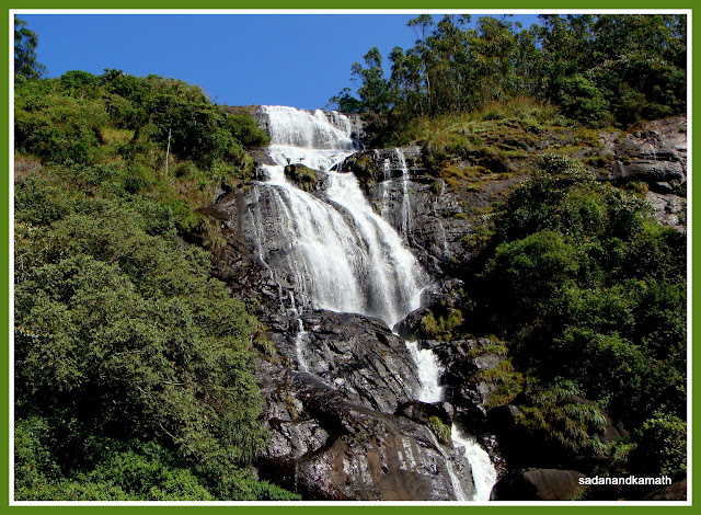
Power House waterfalls
Next, we visited Anayayangal dam. It was a quite place without much of the tourists folks. The lake is surrounded by tea and orange plantations. The view of Chinnakkanal forests was good. For the first time in our trip, we saw some orange plantations in the midst of tea gardens.

Anayayangal lake with tea and orange plantations in the background
The last 20 kms of the road up to Vandanmedu was full of patholes but the entire route was scenic with lines of cardamom planatations and the dense forest cover. We reached Vandanmedu by 2.00 p.m. and checked in Carmelia Haven - a spice plantation resorts (http://www.carmeliahaven.com/ ) which is located 20 kms ahead of Kumily. As we could not get reservation in any of the three properties in the Periyar Sanctuary, we felt that it would be a good experience to stay in a plantation resorts. Indeed, it turned out to be a good but at the cost of forgoing the company of wild-life.

Carmelia Haven cottages surrounded by spice plantations
The afternoon was spent by taking an hour of interesting plantation tour inside the resort premises accompanied by one of the plantation officials. It was a walk through predominently cardamom plantations, though the resort had pepper, cocoa, tea and other herbal plantations.There was a plant whose leaves gave the aroma of all spices. The resort also arranges guided jeep safari its 1500 acres of spices plantations located at Kailasam at extra cost. According to the guide, Vandanmedu is world's largest producer of Cardamom and is also one of the world's largest auction centres of cardamom.
In the evening, we attended Bharatnatyam, Kuchipudi and Mohiniattam dance performances by the local artists, arranged by the resort for its guests.

A cocoa plant with cocoa fruits
Day-5 : Periyar Lake-Thekkady-Kumily
We left Vandanmedu early morning for Periyar lake. The moment we entered the Periyar Sanctuary, we realised how nice it would have been if we could manage to get rooms in one of the three KTDC properties inside the sanctuary. The road to Periyar lake goes through thick forest. The soft sunlight filtering from the forest cover, the pathways littered with leaves, the silence occasionally broken by the jumping langurs - lend the whole area a serene atomsphere. Also staying inside the Periyar sanctuary would have given us some flexibility in managing day walk, boat ride and bamboo rafting as we realised later.

Boarding point for boat ride at Periyar lake
We reached the Periyar lake at around 9.00 a.m. There was a big queue for buying tickets for boat rides scheduled for 9.30 a.m. My first reaction was to forgo the boat rides and instead scout the surrounding areas by walk. But my driver insisted on taking the boat rides and he managed to get the tickets at the last moment. But I was required to walk down to a separate counter located about 100m from the boat ticket window - for paying camera fees. Since the boat was about to leave, we just ran down to get into the boat leaving my camera with the driver.
During the 2 hours of the boat ride, we could, at best, see a couple of bisons and sambars, that too through binocular somewhere in the mid point of the boat ride. However, we sighted from the close range many birds ( one of which, I could recognise was a kingfisher) sitting on their nests constructed on some of the many dead tree stems in the lake. It was a disappointing boat ride with lots of noise created by a group of tourists and wild animals elluding us. Later, we came to know that there was a good chance of sighting elephants in the vicinity of the Periyar lake if we had taken the first boat ride at 7.00 a.m. or the last one at 4.00 p.m. Had we directly driven to Periyar lake in the afternoon on the previous day, perhaps we would have got the 4.oo p.m. boat ride and also a fair chances of sighting elephants.
 One of the elephant sighting places around Periyar lake (picture from mobile camera)
After completion of the boat ride, we proceeded to Thekkady for a 30 minutes elephant ride in a spice plantation. There was nothing exciting about the ride as by now we had enough of spice plantations. But it was a thrilling experience when the elephant put his trunk on our heads as if he was giving his 'blessings' to us. We could feel a heavy weight of his trunk on our heads.

The elephant ride and.......

.....the 'heavy' blessings.
After lunch, we returned to our resort for a full ayurvedic body massage in the last slot of the day at 5.00 p.m. which we had booked earlier in the day. We went to the Ayarvedic Massage Centre where two young men greeted me and led me to a massage room. First, one of them applied herbal oil to my head and face and massaged with different pressure. Thereafter the oil was applied to hands, shoulders and chest followed by a gentle massage and ended with vigourous synchronised massages by both the men. Similar procedure was followed for my legs, back and shoulders after pouring a good quantity of herbal oil. It took about 60 minutes to complete the massage. Thereafter, I was given a steam bath in a box type wooden structure for 15 minutes followed by regular hot water bath. It was a good experience to have a full body massage as we felt fresh and rejuvenated. But I always feel rejuvenated when I am on a visit to hills and mountains!
 |
| One of many rubber plantations on way to Kottayam |
Day- 6 : To Alapphuza
The orginal plan was to drive to Kochi for sight-seeing and stay for overnight stay for departure to Mumbai the next day. But the Kerala Tourism Officer suggested me to stay at Alapphuza and do the Kochi sight-seeing on way to the airport which I agreed. Our intention was to have a relaxed holidays in Alapphuza without doing much of the sight-seeing.
We commenced our journey to Alapphuza at 9.30 in the morning. The road condition up to Kumily was bad. At around Peermeede, there were many tea plantations by the side of the road. But they did not look as attractive they were not as symmetrical laid out as of the Munnar ones. We briefly stopped at Kultikannan and spend sometime near a waterfall. Since Kundai Lip Heritage Resort - the place where we had booked - was located on the northern part of Alapphuza, we took the road via Kottyyam-Kumarkom-Centharala. There were many rubber plantations across the road on the way to Kottyyam. The last one km of the drive to Kondai Lip Heritage Resort ( http://www.kondailip.com/ ) was on a dirt road to reach the parking lot. From here, we were required to take a short ride in a boat to reach the resort's gate. It was 2.00 in the afternoon, when we checked in the resort.
After lunch at the resort's restaurant, we took a round of the property. There were nine cottages built in a traditional Kerala style ( hence named as heritage resort). The attached bathroom to our cottage was big and was opened from the top but there was no problem with the privacy.
 |
Way to Kundai Lip Heritage Resort |
In the evening, we did pedal boating in the backwater canals in the vicinity of the resorts. Riding in the backwaters with pathways lined up with coconut trees in a pleasant weather was a great experience.

Coconut tree lines on the pathway between two canals
Day-7:In Alapphuza-Backwater Cruise to Andhakaranazhi Beach
We got up early in the morning and went for a walk inside the resort. The weather was cool and the sky was covered with a thin layer of mist thus making the sunlight diffused. As the day progressed, the sky became clear and the weather turned warm. After a breakfast of Idliappum, we went for pedal boating in the canals. It was an interesting sight to watch the resort's workers plucking the bunch of coconuts from the trees and throwing them down on the pathways, some of which eventually fell in the canals. The boatman would collect these coconuts and load them in his boat. The activity went on for an hour or so. Some of the guests at the resorts went for fishing in the canals and were successful in some catches.
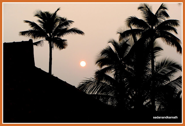
Sunrise view from our cottage

Coconut trees line up at one of the backwater canals of Kundai Lip
It was time to place order for lunch which was required to be given at least two hours in advance if we required fish menu. It is only after placing the order that the resort staff would go to catch the required quantity of fish from its own backwaters for preparation of the dishes ordered. We ordered for grilled tiger prawns which were very tasty.
 |
| Me rowing the boat - great enjoyment |
In the afternoon, on advice and the guidance from one of the guests, I ventured for a solo rowing boat ride. This was my first experience in rowing a boat. At the beginning, I was finding it a bit difficult to control the direction but later on I got the feel of it and started enjoying the rowing. I would have continued the rowing but the strains on hand and calf muscles were too much for a newcomer like me. Also we were told to be ready by 4.00 in the afternoon for a complimentary backwater cruise.
We boarded the Resort's speed boat for a backwater cruise at the appointed time. Surprisingly, there were only four guests as against the capacity of 8. It was about an hour's cruise to Andhakaranazhi beach. As we proceeded away from the resort, the backwater canal become wider. There were hemlets at the shores of the canal and children waved hands to us as we passed by their houses. At many places, there were rows of chinese fishings nets in front of these houses. Occasionally, we also came across rows of dead tree stems - probably fixed by the fishermen to mark the boundaries for fishing. These tree stems and also the fishing nets attracted lots of birds, most of them being the kingfishers. At the mid point of the cruise, we saw an unique scene of birds occupying all the tree stems ( may be more than 20 in numbers) as if they were on display!! After an hour or so, we disembarked near a dirt road and walked for 10 minutes to reach the beach.

One of the chinese fishing nets on the way during backwater cruise
Andhakaranazhi beach is a small strips with hardly any crowd other than some locals who were seen collecting tiny shells that came with the tides, in a gunny bag and later to be sold to one of the factories located nearby. These factories convert them to granules to be used in construction activities. There was nothing else to see in Andhakaranazhi except a newly constructed lighthouse in place of older one which was damaged in the sunami in December 2004.
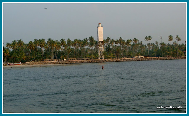
Lighthouse at Andhakaranzhi beach
We did not wait to see the sunset at the beach as we were eager to take the return cruise before dusk so as to see the sceneries in day light. The sunset view through the unending rows of coconut trees from a speed boat was a rewarding one.

Sun about to set in on our return backwater cruise to Kundai Lip
Day-8 : To Kochi and back to Mumbai
Our holidays were coming to an end as we left the resort at around 10.00 in the morning on way to Kochi. We spent some time in visiting Mattanchery Palace, Jew Synagogue and took a walk in Fort Kochi. After lunch, we were to do some window shopping in Ernakulam but we found most of the shops closed as it was Sunday.

Jew Street in Fort Cochi on a Sunday

Wellington ferry boat at Mattanchery jetty

Display at one of the shops at Jew Street
As we drove from Ernakulam to Kochi airport, we realised that that our Kerala holidays were the most relaxed one we ever had in the last few years and we enjoyed every bit of it. Some time back, my wife had reminded me that it was time for us to plan for revisits to Ooty and Kodaikanal which we had visited in December 1975 and 1980, respectively. Yes, soon we will have another relaxed holiday in Ooty or Kodaikanal.
More photos here.
More photos here.


