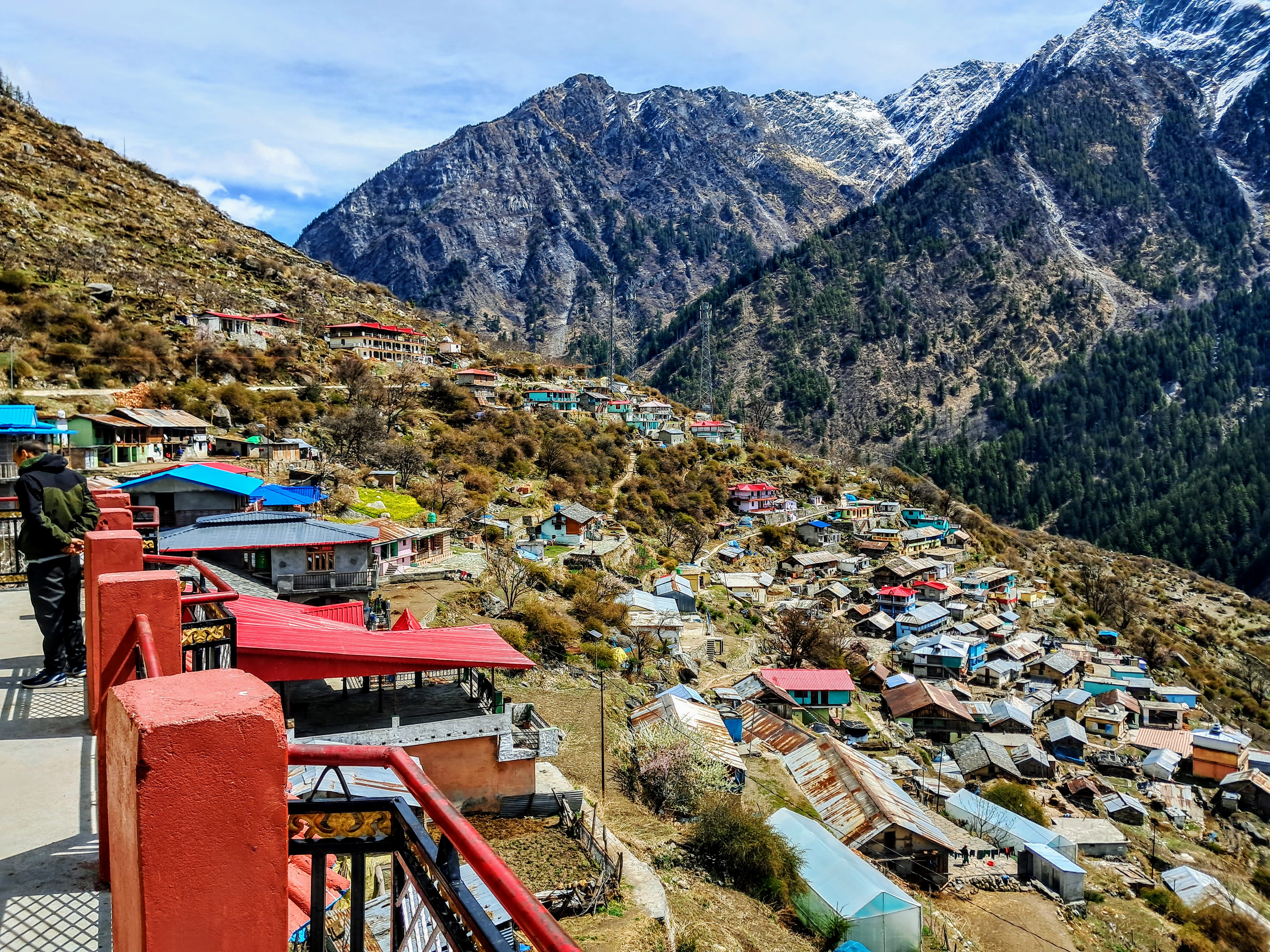
In October 2022, during my rambling in Uttarkashi district, I had visited Gartang Gali from Lanka bridge on Gangotri road. This was the only route, a pedestrian path, till 1962 for people of Nelong, Jadhang and Naga villages to undertake cross-border barter trade with Tibet. People of these villages had to carry goods bought from the Indian side markets through Gartang Gali pedestrian path which was the shortest route to the nearest Nelong village (around 30 kms) for onward journey to Tibetan border. Incidentally, this was the route which Austrian mountaineer, Heinrich Harrer used for his escape from India to Tibet from the clutches of British soldiers during World War-II. He spent 7 years in Tibet.
After the Indo-China war of 1962, this route was closed by army and people staying in 3 border villages were shifted lock, stock and barrel. With Indo-Tibet trade on this route coming to a virtual end, there was a problem for the people of these three borders villages who were deprived of their livelihood. Government gave them free houses in Bagori village in Harsil Valley and in Dunda near Uttarkashi. They were given the status of scheduled tribe to get them preference in employment in Government and semi-government undertakings. They were also given the free ration and children were given free education. I understand that many of the current generation of family from 3 border villages are well educated and some of them have settled in Dehradun.
Since 1962, this pedestrian path has remained unused for nearly six decades. On this path, there is a wooden stairway of about 140m length which is fixed partly by cutting the vertical granite rocky mountain and partly hanging over Jadh Ganga River with wooden sleepers and railings. In 2020, the wooden stairway was repaired extensively by PWD, Bhatwadi and it was opened for tourists in limited numbers from August 2021. Depending upon the snow conditions, the Gartang Gali is opened for tourists from April to November. Tourists intending to visit Gartang Gali are required to register their names on the spot at the Forest Check Post near Lanka bridge with Aadhar Cards (or other eligible photo identity cards) and pay the entry fee of Rs.150/- per head.
After 1962 Indo-China war, the army has constructed a road from Bhaironghati (on the opposite side of the mountain from Gartang Gali) up to the Tibetan border covering all the three villages mentioned above. The road was opened in 1975 only for army and para-military forces. No civilians were permitted to cross the check-post at Bhaironghati for Nelong valley. Even the original inhabitants of three border villages were not allowed to visit their homes except for one day during the first week of June every year for conducting prayers at Lal Devta temple.
From May 2015 onwards, the authorities have opened for very limited tourists to visit Nelong Valley up to ITBP Check-Post (25 kms of road journey from Bhaironghati Forest Check-Post). Initially, the tourists were required to use only Forest department's vehicles (4-wheel drive) each carrying not more than 4 persons and not more than six vehicles a day. With the improvement in the road condition, one can travel in their own/hired SUVs. Overnight stay in Nelong Valley is not allowed.
Drive to Nelong Valley - April 03, 2023
I was keen to travel to Nelong Valley in my last October 2022 visit. Unfortunately, I was not aware of the cumbersome procedure for obtaining a permit from Sub District Magistrate, Uttarkashi which may take 2-3 days because of multiple agencies involved in the clearance of permit. So, I abandoned the plan of visiting Nelong Valley at that time.
A window of opportunity came to me when my son showed a keen interest in replicating my October 2022 visit to Uttarkashi district during the first week of April 2023. My friend, Tilak Soni of Eagles Nest in Mando, Uttarkashi who was my host in October 2022 as well as in April 2023 informed me that this year, Nelong Valley will open for limited tourists from April 1, 2023, as snow had cleared from the road earlier than expected. In fact, he was one of the first visitors to Nelong Valley on the opening day. He suggested that we should make a visit to Nelong Valley, and he would help me in getting the Inner Line Permit. I at once jumped on his suggestion and sent the required documents in advance for processing for the issuance of permit. We landed at Eagles Nest on April 1st, and we had the permit to visit Nelong Valley for April 3, 2023.
Tilak ji explained to me the procedure for obtaining the Inner Line Permit for Nelong Valley. The application for the permit is first submitted at Sub-District Magistrate's (SDM) Office in Uttarkashi along with the photocopies of Aadhar Cards of visiting tourists. If the vehicle is to be hired for the purpose, the name of the driver, copy of his Aadhar Card and the vehicle registration number have to be given. If the documents are in order, SDM office will stamp the application with instructions to submit the same in the office of Superintendent of Police (SP), Uttarkashi for police verification. This may take a day or two depending upon the availability of SP. After getting the police clearance from SP. the same application is carried to SDM office who will issue the Inner Line Permit. I understand from Tilak ji that the SDM will put the system of issuance of ILP on-line shortly to make it a single window clearance for the prospective visitors to Nelong Valley.
The photocopy of the Permit for Nelong Valley. Please note that the applicant has to give the name of the driver and the SUV registration number in advance.
The route map to Nelong Valley
The Scorpio vehicle arranged by Tilak ji arrived on time. After a sumptuous breakfast of Idli-Sambhar-Coconut Chatney and the Masala Dosa followed by an authentic South Indian filter coffee - all items personally prepared and cooked by Tilak ji, we commenced our dream journey of Nelong Valley (109 kms) from Uttarkashi at around 09:15 hours with our driver, Sandeep Semwal who is also the Sarpanch of Sangrali village (11 kms from Uttarkashi). The weather was fairly clear with some patches of white cloud formation at the higher level. It was cold and windy even in bright sunshine when we reached Sukhi Top (3290m altitude). We took a small break here for taking pictures of breathtaking sceneries.
View of winding road from Jhala to Sukhi Top.
Jhala village (right below) at the shore of Bhagirathi River seen from Sukhi Top (3290m)
The author on Sukhi Top
Sukhi village from Sukhi Top.
We proceeded to Bhaironghati from where the road to Gangotri (10 kms) goes towards right. The left diversion is the Nelong Valley road where there is a forest department's check-post. The Gangotri temple, the Nelong Valley and the Gartang Gali are the part of the Gangotri National Park. At the forest department check-post, our permit was checked along with our Aadhar Cards. Since the original permit was to be retained by the forest officer, we took a screen shot of the permit on our mobile. We paid Rs.550/- (Rs.150/- each for 2 tourists and Rs.250/- for the vehicle). The road journey is allowed up to the ITBP check post in Nelong Valley (25 kms from Bhaironghati). Overnight stay is not allowed on any part of Nelong Valley. Two Wheelers are not allowed on Nelong Valley road.
Forest Check-Post on Nelong road. The right turn to Gangotri temple (10 kms)
It took hardly 5 minutes to check the permit and collect the fees. Now the moment of 'dream comes true' has caught me to view the Nelong Valley. I had seen the road from Gartang Gali trek from the opposite mountain which looked precarious with rock hangings. However, the road's surface was not visible from the trek path which gave me an impression of a rough surface with bumpy rides. It was, however, a pleasant surprise for us that it was two-lane tarred road with a smooth surface. The hanging granite rocks from the mountain were not as menacing as looked from Gartang Gali trek path. The mountain on the right was of solid granite rocks. It is also surprising to note that the adjunct mountain on Gangotri road is very fragile resulting in frequent mudslides during rains.
The first 1 km of road to Nelong Valley. It is wide two-lane road.

A small patch of tarred road where the broken rock fragments got accumulated probably carried by snow in winter. The mountain on the left looks solid with granite rocks.
As we drove further ahead, the vegetation on the mountain on our right became thinner. After about 5 kms of drive from Bhaironghati, we saw the full length of about 140 metre of Gartang Gali wooden stairway which appeared to me of about 45-degree gradient from the starting point on the left to the finishing point on the right as seen from Nelong Valley road.
Author is clicking from Nelong road, the photo of Gartang Gali wooden stairway on the opposite mountain.
Gartang Gali wooden stairway with Jadh Ganga River in the valley clicked from Nelong road.
A close up shot of Gartang Gali stairway from Nelong road.
The rest of the road journey was fairly smooth except some three places where due to ongoing construction of RCC bridges over streams, we had to drive the vehicle via a short diversion on mud road. Another feature of Nelong road is that there are very few sharp bends on the way. Also, ascent on the road is very gradual. The smoothness of the road can be judged by the fact that it took us about 40 minutes to cover a distance of 25 kms to reach Nelong Valley by 13:00 hours which is a good for a mountain driving. The ITBP police did not check any papers but advised us to stroll in a designated places and avoid going on snow field.Nelong road
One-km to Nelong Valley Check-Post.
From ITBP Check-Post, the author is walking towards the snow field just to observe the snow-capped mountains from the close range.
The author is walking from the ITBP Check-Post. One can clearly see the Ladakh type coloured mountains in the back.
After getting down from the vehicle, the first thing we experienced was some light dizziness even though it was a plain walk. We were also experiencing a slight breathlessness. Probably, this was the effect of reaching a higher altitude in short span of time. We had started from Uttarkashi which was at an altitude of 1160m. In about less than 4 hours, we were at a significantly higher altitude of around 3450m. We got ourselves adjusted by walking slowly and standing at one place for a couple of minutes until the breathing became normal. Even in mid-day, there was a strong cold breeze blowing with hissing sound. No doubt, Nelong Valley is called the cold desert of Uttarakhand.
Nelong Valley is a part of Gangotri National Park which have the endangered wildlife such as snow leopards, musk deers, blue sheep (Bharal) etc.
Snow-capped mountains from Nelong Valley.
The author standing with the backdrop of snow-clad mountains in Nelong Valley.
The author coming out of one of army bunkers in Nelong Valley
After strolling for an hour or so in the cold breeze, we came back to ITBP Check-Post. After about a walk of about 100 metre, we came across a plain area where we decided to have packed lunch of Parathas and the dry Aaloo Subzi which Tilak ji had kindly prepared in the morning for us. It was the time for a goodbye to Nelong Valley which I had not even planned in my itinerary. The visit to Nelong Valley was a God-sent gift to me which was handed over to me through his 'Devdoot' in Uttarkashi.
The icing on the cake was that in our return journey, we got to see three musk deers crossing the first bend of Nelong road leaving the Nelong Valley. We reached Harsil by 15.30 hours. We checked in our pre-booked Sundar Homestay which will be our 'nest' for three nights.
Three musk deers (on the left) waiting after crossing the Nelong road before a BRO truck comes from right.
Sundar Homestay, our 'aashiyana' for three nights in Harsil.
Soon after check-in, rain showers started which continued intermittently until the late evening. We had to drop the idea of a walk through Bagori village in the evening and carry forward for the next day. We could see from our room balcony that the upper reaches of region near Harsil Horns had received fresh snow fall. The midnight temperature at Harsil was forecasted to a minimum of 1 degree Celsius.
Trek to Gartang Gali - April 04, 2023.
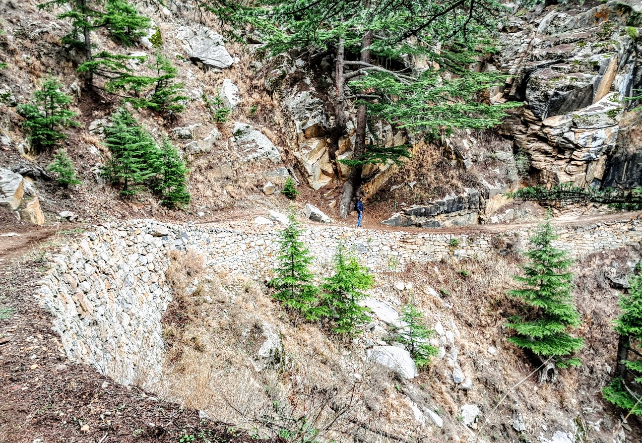
Having drove through Nelong Valley road yesterday, today was yet another time for me to replicate Jadh-Bhotia traders who used pedestrian path through Gartang Gali to reach the Nelong Valley 6 decade back. This time, the trek to Gartang Gali gives me an opportunity to compare the topography of Nelong Valley road versus Gartang Gali trek, though to a limited extent, as we are not permitted to trek beyond the end of wooden stairway which works out to barely 2 kms of trek.
We commenced our journey from Harsil at around 09:00 hours in a cloudy weather with diffused sun light piercing through the thin layer of cloud. Today Sukhi Top did not have the grand-stand views because of the cloudy weather. So, we drove non-stop toward Lanka bridge where the Forest Check-Post for Gartang Gali is located. After completing the registration formalities, we commenced our trek. It appeared that we were the first tourist of the day for Gartang Gali trek. Since I had already covered my Gartang Gali trek of about six months back in a Blog, I will skip the details. I will post few pictures of the trek which will be self-explanatory. The initial trek path of Gartang Gali.
The climb.

The start of wooden stairway in the background with Jadh Ganga River on the right.
A large protruding rock hanging above the wooden stairway with Jadh Ganga River on the right.
The end point of Gartang Gali trek as well as the wooden stairway. No one is permitted to cross beyond this point.
The stairway railing with Jadh Ganga river on the left.
The end of the trek outside the forest check post.
Having allowed the tourist to trek Gartang Gali since August 2021, the moot point is as to why the forest department has restricted the access to Gartang Gali up to the end of wooden stairway? My friend, Tilak Soni had visited the entire Gartang Gali till the base of Jadh Ganga River, about 5 kms beyond the end of wooden stairway. He was a part of forest department's team to reconnaissance the trek path. So, I thought he was the right person to shed some lights on this matter. He told me that at some places, the trek path was badly damaged which required major restoration works. Also, the 100+ years old rickety wooden bridge over Jadh Ganga River connecting Gartang Gali trek route with Nelong Valley (now Nelong road) had collapsed. So, the Government of Uttarakhand has to work out the cost estimation for restoration of the trek path as also the construction of a pedestrian suspension bridge over Jadh Ganga River to connect the trek route, say at Karchha, about 8 kms from Bhaironghati on Nelong road. Let us hope that the authorities would get the budget sanctioned for restoration of the trekking path beyond wooden stairway.
We completed the Gartang Gali trek (to and fro) in 2:30 hours with lots of break for photography. From Lanka bridge, we proceeded to Gangotri temple (12 kms) where the refurbishing of the temple was in progress before the start of Chardham Yatra on April 22, 2023. The weather had improved from cloudy to a sunshine.
While returning from Gangotri, we took a break at Dharali to visit 'below the ground level' Kalp Kedar temple. It is said that the temple is many centuries old, probably belonging to the
Pandavas time. There is also a theory that the snout of the Gangotri glacier
was located near the temple from where Bhagirathi River originated. Over a
period of time, the Gangotri glacier receded due to climate changes and now the
snout of the Gangotri glacier is located at Gaumukh.
Kalp
Kedar is an interesting and unique temple. It is at least 25 feet below the
ground surface. It is said that the temple which was on the banks of Bhagirathi
River got submerged in flood waters during the annual flooding. The sediments brought
during the flooding over many years covered the temple with only shikara of the
temple visible above the ground level. Two subsidiary temples – Parvati and
Ganesh – were washed away in the floods. In 1980, the temple was excavated but
still about 5-10 feet of the temple base is submerged in the water depending
upon the level of water of Bhagirathi River, now flowing about 300m away from
the temple. The temple has the Panchmukhi Shivling which remains submerged in
water. Hence, it is not possible for devotees to worship inside the temple. So,
a Shivling has been installed outside the temple for devotees to worship. Once
in a year (in the month of Shravan), the water from the temple is pumped out. The
priest goes inside the temple to wash the Panchmukhi Shivling with the fresh
underground water flowing from Bhagirathi River. The temple is a protected
monument under Archaeological Survey of India
We reached back Harsil around 15.30 hours.
Kalp Kedar temple, Dharali.
The main door of the temple remains submerged in water throughout the year
A sculpture of Kaal Bhairav adorns the main door of the temple. A Shivling has been installed outside the temple for devotees to worship.
The location of Kalp Kedar temple in Dharali village. Now Bhagirathi River is flowing at least 300m away from the temple.
Having done the drive to Nelong Valley and trek to Gartang Gali in more or less the same timeframe, I find in these visits, the different kind adventures and the topography. The drive to Nelong Valley is all along the true left of Jadh Ganga River with mountain devoid of much of vegetation. One gets a feel of driving on the road from Leh to Kargil. Also, the Valley is located at an average altitude of around 3400m.
On the other hand, the trek path to Gartang Gali is through the dense forest located on the true right side of Jadh Ganga River. The highest altitude on this route is around 3000m. The walking on a wooden stairway which is partly hanging over Jadh Ganga River flowing about 300m down, gives a feel of a different kind of adventure.
When the Gartang Gali trek is fully opened, the tourists will have a choice to see the Nelong Valley - by the comfort of driving on Nelong road or trek through dense forest on Gartang Gali. One may also come across endangered wildlife species such as musk deers and blue sheep as we saw them during our visit to both these routes.


.jpg)


1 comment:
awesome story SK, with historical perspective. nice read. thanks!
Post a Comment