Long and tiring journey to Joshimath
After 21 hours of train journey from Mumbai, we reached New Delhi at 11.00 a.m. Due to intense heat, we decided to spend the next 4 hours in the relatively cool comfort of waiting room before boarding a 3.25 p.m. Janashatabdi Express for Haridwar. The train reached Haridwar at 7.35 p.m. We took an auto for Rishikesh and stayed in a hotel near Sanyukta Yatayat Bus stand. The idea of staying in Rishikesh was to get an hour of lead time for the next day's long journey to Joshimath. We dropped the idea of taking a car for Rishikesh-Joshimath as the charges @Rs.4000/- for Joshimath drop was too high. Share jeeps were not plying from Rishikesh direct to Joshimath. Probably we would have to change the share-jeeps at Rudraprayag and then again at Karnaprayag/Chamoli to reach Joshimath. So we booked seats on our least preferred mode of transport – bus leaving Rishikesh at 4.00 a.m. @Rs.230/- per head.
Next day we got up at 3.00 a.m. in the morning to catch the bus for Joshimath. The bus eventually crossed the RTO check point at Rishikesh around 4.30 a.m. The journey was most uncomfortable as the space between rows of seats were so cramped that the space was not sufficient to keep our legs without hitting our knees backside of the seat next to us. Furthermore, the seats were so small that it was not possible even for normally built persons to sit with a bear comfort. A young man occupying seat in the middle low slipped from his seat twice. It was only when the bus was full with standing passengers that he was secured from further fall. At Srinagar, bus stopped for breakfast and KS almost decided to abandon the bus journey as he could no longer sit in cramped space. He was later accommodated adjunct to the driver’s seat so that he could move his legs albeit to a limited extent. After a lunch break at Pipalkoti, we reached Joshimath at 3.00 p.m.
In retrospect, we felt that travelling 250 kms in 11 hours on hill road in a cramped seating arrangement was too much for oldies like us especially when we were going for 10-day treks in which our legs were the most important assets for trekking. It would have been better if we had taken an overnight halt - say at Rudraprayag. KS was already feeling a mild low back pain and hoped that he would get over it as the next day was the rest day. In the evening Sohan Singh Bisht (Sonu), our guide contacted me from his mobile that he was at Kuari Pass and would reach Joshimath by 8.00 p.m. I told him that he could meet us next day morning.
In Joshimath
It was a rest day for us at Joshimath. Sonu came in the morning for collecting our photographs and copies of photo identity cards for taking permits for Kuari Pass and Nanda Devi Outer Sanctuary (NDOS) treks. It may be noted that Trekking beyond Auli ( i.e.,beyond the last cable car tower) requires DFO’s permission and taking a local guide from Agencies authorised by DFO is a must for Kuari Pass trek via Auli.
Sonu apprised us of the fact that drinking water was not available both at Talli and Chitrakantha camp sites and we may to skip these camps in favour of Khullara and Gailgarh. Other information he gave us was that the Lata Kharak Forest log huts and Dharansi camp site were fully occupied by the jawans of Gorkha Regiment for providing logistic support to their expedition to Trishul I. Furthermore, there was already water scarcity in Dharansi Camp. He suggested that we could take a day trek to Dharansi Pass and come back to Lata Kharak camp as there was water problem at Jhandidar camp site as well. It rained in the evening bringing down the temperature in Joshimath. I could also see some fresh snow on the Chinap Valley side mountains.

Joshimath-Auli (2585m)-Gorson (3380m) [14kms by Jeep + 8 kms by trek]
We left Joshimath around 8.30 a.m. by jeep and commenced the trek from Auli helipad. At the last cable car tower, our permit was checked by an official of DFO. From here, our trek was mostly through oak forest and bugyals. The gradual climbs took us to Padiyar Temple where we had packed lunch. After the temple, it was an easy walk over bugyals which were green thanks to almost daily afternoon/evening rains in the last few days. After ascertaining the water source, we camped at Gorson bugyal just one km short of Gorson top.


As our tents were being pitched, it started raining. What was thought to be a passing showers soon turned into heavy rains, then to hail storm which continued for about 3 hours. There was some danger of our kitchen tent collapsing due to heavy accumulation of hails on the tent roof. KS used his walking stick to dislodge the accumulated hails. At around 4.00 p.m. the rains abated. But the rains and hails brought down the temperature from 18C at 1.00 p.m. to 11C at 4.00 p.m. The hot sweet corn vegetable soup prepared by Sonu never tasted as good as in Gorson. Fortunately, we did not face any altitude related complications though we had gained 1300m of altitude in a single day.

Gorson (3380m)-Khullara (3395m) [10 kms by trek]
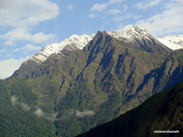
The morning was cloudy and misty as we came out of our tent at around 5.00 a.m. But soon the cloud and mist got cleared as sun came out and we got the clear view of Neelkanth, Hathi and Ghodi peaks. As we were getting ready for departure to Khullara, we could see Mana, and Nilgiri peaks also. After 1 km of gradual climb over the bugyal, we reached a table top just below the Gorson Top where we met a group of trekkers from Kharagpur who has started their trek from Ghat side. The place was good for peak viewing as apart from Hathi, Ghodi and Neelkanth peaks, we could see Nanda Ghunti and Ronti peaks and the deep Dhauliganga valley.


After this point, the next 2 kms of trek involved steep climb and descends at some places on a narrow path with almost vertical cliff on one side and the steep valley on the other side. We walked slowly taking support of the cliff side. Thereafter it was downhill all the way to Talli lake and then to Talli campsite through the dense forest of oak and rhododendron. Since both Talli and Chitrakantha had no drinking water sources, we had earlier decided to proceed to Khullara for camping as it had good water source. From here, it was a gradual climb through the mix forest of rhododendron, pine and birch trees followed by a level walk of about one km to Khullara. The peak view from Khullara was better than that of Gorson. Peaks such as Dunagiri, Hathi, Ghodi, Kamet, Mana, Nandaghunti (west face) were clearly visible as sky was clear.


In the evening, we spotted a wild cat just about 100m behind our kitchen tent. It was about 2 feet of length with dark creamy tail and brown body. The cat looked at us for few seconds when we were standing near a bonfire and vanished under the forest cover. We had an excellent sunset views of Dunagiri and Nanda Ghunti peaks.


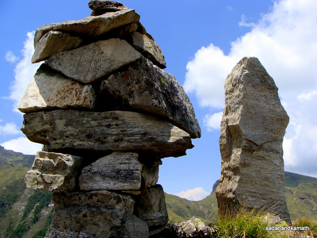
KS had a disturbed sleep in the last night and he felt that a day’s rest will rejuvenate him for the Kuari Pass trek. In any case, we were one day ahead of our schedule. While KS rested in his tent and slept well, I and Sonu decided to make a short trek to Khullara Top, about 3 kms of climb from Khullara campsite. In fact, those trekkers who make Chitrakantha as campsite usually trek to Khullara Top on their way to Gailgarh via Khullara ridge. After 2 kms of steep climb, some of which were on boulders and scree followed by a level walk on the ridge, we reached Khullara Top cairns. The view of peaks as well as well as 360 degree view of bugyals – Chitrakantha, Khullara, Gailgarh from Khulara Top were superb.

Hathi and Ghodi parvats from Khullara campsite.

Kamet, Mana, Neelkanth and Nilgiri peaks from Khullara campsite.

Wildflowers at Khullara.

Mules at Khullara campsite.

Khullara campsite seen on way to Khullara Top.

Me on Khullara Top.

At around 7.00 p.m, heavy showers accompanied by gusty winds shook our tent. Soon showers turned into hails. We did not know when the rain stopped as we must be in deep slumber in our sleeping bags. In between, I heard Sonu’s voice outside our tent instructing a porter to strengthen our tent’s strings with extra nails. The next day, he told me that after watching 2-3 tents being lifted out of the ground and then falling some 10 feet away at Bedni Bugyal about a month back when rain accompanied by gusty wind hit the bugyal, he has started taking extra precaution in pitching the tents.

Khullara-Kuari Pass (3840m)-Khullara-Dano Kharak (3015m) [5+5+3 kms trek]
What a beautiful morning it was with no traces of any cloud for an uninterrupted view of snow-capped Himalayan peaks from Kuari Pass! It was our coldest morning of the trek with temperature around 4C. After an hurried breakfast, we commenced our 3 kms climb from Khullara to Gailgarh tri-junction where treks from Chitrakantha, Khullara and Kuari Pass meet. A gradual climb over the ridge just above the Kuari Pass trek leads to Pangarchula peak while path just below the ridge goes to Kuari Pass. After one km of level walk, we reached near a camping ground. We saw a trekking group winding up the camp after completion of their early morning trek to Kuari Pass. The guide of the tekking group told us that they had come on the previous day from Dakwani to Kuari Pass but they could not see any peak due to cloudy weather So they decided to stay at this campsite which was about one km below the Kuari Pass on Gailgarh side. The group was quite happy when they had a superb sun rise view of all the peaks from the pass.


I was disappointed from Kuari Pass for a different reason. I recall my September 1995 Kuari Pass trek from Ghat when after 4 days of trekking I seldom came across any peaks except, perhaps at Pana when I could see one or two distanced snow-capped peaks. After a steep climb from Dakwani in the shadow of Kuari Pass and climbing the last step to reach Kuari Pass, it was the most thrilling moment for me to see almost 180 degree view of peaks. There was no such thrill this time as we have been seeing peaks right from Auli and as we progressed towards Kuari Pass, the peak view increased and the element of thrill diminished.
An interesting discussion took place between Sonu and me as to which was the real Kuari Pass - Gailgarh side pass which we have crossed today or Dakwani side pass which I crossed in 1995 (and also crossed Gailgarh side pass on my way to Tapovan). Sonu said that the pass was a point of place where one had to climb to reach it after which it led to descend. Kuari Pass from Gailgarh qualified as the real pass as we started climbing from Gailgarh and after reaching the pass, there was a descend all the way to Dakwani. On the basis of this logic, Kuari Pass from Dakwani did not qualify as a pass because after climbing from Dakwani one crossed Kuari Pass but the climb continued till Gailgarh side pass was crossed after which it was descend all the way to Gailgarh. Whatever the experts may say on this issue, I was impressed by Sonu's rationale explanation.

After spending about 30 minutes on the pass, we started the return journey. The weather was excellent for trekking. We reached Khullara camp by 11.45 a.m. After lunch and winding up of our camp, we started our down hill trek to Dano Kharak around 1.45 p.m. Though we could have made to the road head at Dhak village by evening, it would have been too tiring for us as the trek was a continuous steep descend often on stony path and scree. Within an hour or so, we reached Dano Kharak camp side which was located adjunct to summer village comprising of about 15 houses. There was no water source at any place until Dano Kharak. Villagers stay here in summer months to tend their livestock, mainly cows, due to good quality grass on the bugyals. They mainly sell ghee in around Joshimath.

Dhano Kharak campsite.

Dano village children are amused by finding us in the tent.
In the evening, Sonu served us mixed vegetable soup with pakodas made of cabbage, capsicum, cauliflower, potato, as side dish. Being the last day of the camp kitchen, perhaps he wanted to finish all left over vegetables. But for us, it was a perfect end to our first phase of the trek in a chilly evening.


Dano Kharak-Dhak-Joshimath [ 9 kms by trek+12 kms by Jeep]
As per our schedule, we were to get down to road head at Tapovan to proceed to Lata summer village to start our second phase of the trek. But Sonu suggested that we get down to Dhak village as the descendwas less steeper than the one to Tapaovan. At Dhak, the jeep will take us to Lata and he and his porters will proceed to Joshimath as he had to get the copy of the NDOS permit and also arrange for fresh provisions for food for our second phase of the trek. Since the NDOS permit was yet to be obtained, we decided that it would be better if we also proceed to Joshimath in case our presence was required at DFO in connection with the permit.

Thuner trees near Dano Kharak on way to Dhak.
As we were about to leave Dano Kharak, Sonu showed me a tree just opposite our kitchen tent whose numbers. I came to know later the local name of the tree as Thuner ( Himalayan Yew). According to Sonu, local inhabitants (mostly bhotias) use the bark of the tree as panacea for various ailments. The barks are first dried under the sun, make powder out of it which is used for brewing namkin chai (salt tea). The villagers believe that early morning drinking of brew made from the bark powder overcome cold, cough and bronchitis. The paste made from the bark if applied on the forehead and other parts of the body is supposed to cure head-ache and rheumatic pain. Also the wood of the thuner tree is used for making furniture. I saw few thuner trees around Dano forest, all of which were stripped of their barks. The branches of these trees were already showing signs of drying. It is no surprise as to why the numbers of these trees are dwindling as told to me by Sonu.

Dano Kharak bugyal. In the background is Gangapar village across Dhauliganga.

We started our last phase of the Kuari Pass trek at 8.00 a.m. It was all the way steep descends until we reached Karchhi village from where it was more or less level walk up to a View Point platform. Here we took break for a packed lunch while admiring the superb view of Dhualiganga valley and villages on the higher slopes. From here, Sonu contacted his driver friend through his mobile to bring his jeep in the next 45 minutes to the road head of Dhak village which meant that we had another 45 minutes of trekking left to reach the road head at around 11.30 a.m.. The jeep arrived on time as we were on the last descend towards road head. Within 30 minutes, we were at our Joshimath Hotel.
Although there were some disappointment at Kuari Pass, we enjoyed the trek immensely because of favourable weather conditions for trekking, greener bugyals all the way from Gorson to Kuari Pass to Dano Kharak, thanks to almost daily afternoon/evening rains and above all the good company of Sonu and his porters who made sure that we were not inconvenienced in any way. The quality of food served during the trek was the best that I have ever got on my earlier treks done so far. Lastly, the Kuari Pass trek did helped us to get acclimatised for a more demanding NDOS trek ahead.
*********
17 comments:
Can you pls share the guide's mob. no.
Mob: 09410365281
Hi,
We've just arrive to Rishikesh. We plan to do the Kuari and/or Milam glacier trek. Do you have the gps track? Will be to helpful to us.
Excellent web.
Thanks
Hi Sadanand
Indeed a very good blog, I am Parag from Pune planning to for Kuari Pass in coming September and would like to have a word with you about the same.
Will you please share your mobile number or email address?
You can reach me at salasakar@gmail.com
Parag Salasakar
I have sent you E-Mail.
Hello Mr. Kamath,
Just had a few queries .. We are planning to go to Kuari Pass in June first week so wanted to ask that do you have any idea about the distance of Pangarchulla peak from Khullara and can it be clubbed with Kuari pass and if yes then how many days would be added to the trek ??
We had not attempted Pangarchulla peak on our way to Kuari Pass. But I had seen the route visible from the base of Kuari Pass. Based on my assessment, I think you may consider doing the trek as under :
Khullara-Kuari Pass. Overnight camp at the base of Kuari Pass. I had seen the water source at the base of the pass.
Kuari Base - Pangarchulla peak-Khullara.
I have no idea about the distance from the campsite below Kuari Pass to Pangarchulla peak. Based on what I had seen from Kuari Pass, I guess it is possible to complete the Pangarchulla peak trek and come back for overnight stay at Khullara in a single day. Since you are going in early June, most of the snow would have melted on the way to Pangarchulla. Still, it is better to start from the camp very early in the morning based on the assessment of the snow condition.
By the way, when we visited Kuari Pass in June 2010, there was no snow on the pass and I could see only the scattered snow on Pangarchulla route.
Recently 5 of us trekked to Bhavishya Badri from Joshimath via hot sulphur springs at Tapovan. Your blog was of great help to us.We also had Sonu as our guide.He was indeed
an icing on the cake.
Very nice post. An ideal destination for indulging in some fun and frolic as Auli is an established location for ski resorts. Also, when it comes to accommodation, hotels in Auli offer excellent accommodation facilities to the tourists and visitors coming to this budding tourist destination.
Nicely written. Photographs are also wonferful
Hi sir,
Just checked out your blog. a very good and nice blog.
Would like to contact you can you please share your email and mobile number at santoshjoshi2003 at the rate gmail dot com
I have Gone through a blog, the blog having a Wonderful story and amazing Photo, Photo Really Describe How Location is Beautiful, Now, I am Planning to Go through that Place Trek to Kuari Pass
Excellent. So well documented for future trekkers. Is Sonu's mobile number still the same ?
Post a Comment